

INTEGRATED MANAGEMENT OF LAND BASED ACTIVITIES
IN THE SûO FRANCISCO RIVER BASIN PROJECT
ANA/GEF/UNEP/OAS
Subproject 2.4 - STUDY OF THE LOW SûO FRANCISCO MARGINS
EROSIVE PROCESS AND THEIR EFFECTS IN THE RIVER
SEDIMENTATION DYNAMICS
Executive Summary of the Final Report
STUDY OF THE LOW SûO FRANCISCO MARGINS
EROSIVE PROCESS AND THEIR EFFECTS IN THE RIVER
SEDIMENTATION DYNAMICS
FundaÓÐo de
Universidade
Apoio a Pesquisa e
Federal de Sergipe
ExtensÐo de Sergipe
Aracaju - SE
INTEGRATED MANAGEMENT OF LAND BASED ACTIVITIES
IN THE SûO FRANCISCO RIVER BASIN PROJECT
ANA/GEF/UNEP/OAS
Subproject 2.4 - STUDY OF THE LOW SûO FRANCISCO MARGINS
EROSIVE PROCESS AND THEIR EFFECTS IN THE RIVER
SEDIMENTATION DYNAMICS
Executive Summary of the Final Report
STUDY OF THE LOW SûO FRANCISCO MARGINS
EROSIVE PROCESS AND THEIR EFFECTS IN THE RIVER
SEDIMENTATION DYNAMICS
Coordinator
Luiz Carlos da Silveira Fontes
Departamento de Engenharia Agron¶mica
Universidade Federal de Sergipe
Researchers
Francisco Sandro Rodrigues Holanda UFS
Ana PatrÚcia Barreto Casado UFS
CÚcero Marques dos Santos UFS
Edgardo Emanuel Latrubesse UFG
Sandra Baptista Cunha UFF
Rivaldo Couto dos Santos Jºnior UFAL
April 2003
STUDY OF THE LOW SûO FRANCISCO MARGINS EROSIVE PROCESS
AND THEIR EFFECTS IN THE RIVER SEDIMENTATION DYNAMICS
EXECUTIVE SUMMARY
INTRODUCTION
The present report presents the results obtained by the subproject 2.4 - Study of the Low SÐo
Francisco Margins Erosive Process and Their Effects in the River Sedimentation Dynamics,
as part of GEF SÐo Francisco project, executed and coordinated by the Universidade Federal
de Sergipe, in partnership with the Superintendõncia de Recursos HÚdricos do Estado de
Sergipe and the Companhia de Desenvolvimento dos Vales do SÐo Francisco e ParnaÚba.
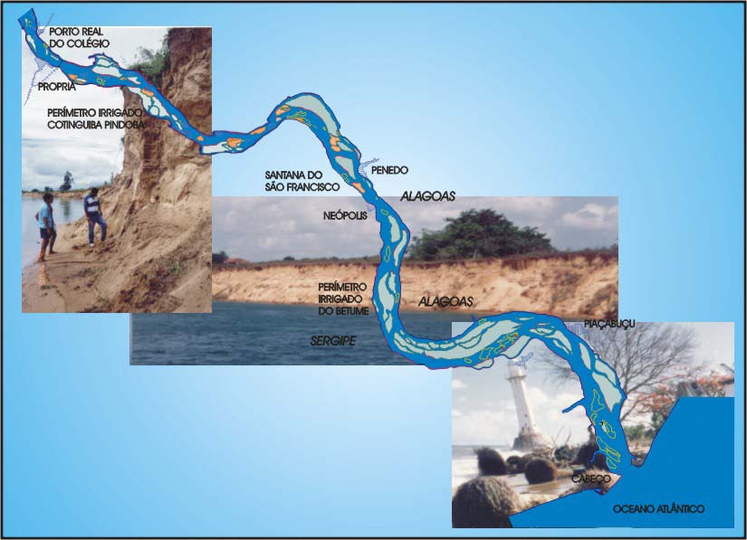
The studied area belongs to the SÐo Francisco hydrographic river basin, more precisely to the
physiographic area of low SÐo Francisco (Figure 1). The study object was the channel in the
SÐo Francisco River low course and their margins, in the stretch between the city of PropriÃ
(Sergipe), in the boundary between the States of Sergipe and Alagoas, and its mouth, in the
Atlantic Ocean, with an approximated extension of 75 kilometers.
However, the actual fluvial dynamics
behavior analyzes extended till the Xingµ
Dam, in CanindÕ do SÐo Francisco,
approximately 240 km distant to the mouth.
In the present report, the stretch between the
Xingµ Dam and the mouth will be
considered the SÐo Francisco River low
course.
An 11 km stretch in the SÐo Francisco right
margin (Sergipe margin), located in the
Cotinguiba-Pindoba Irrigated Perimeter
(District of PropriÃ), was studied in larger
details, including monitoring and
quantification of the erosion and studies of
slopes stability (Figure 2).
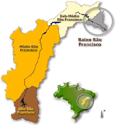
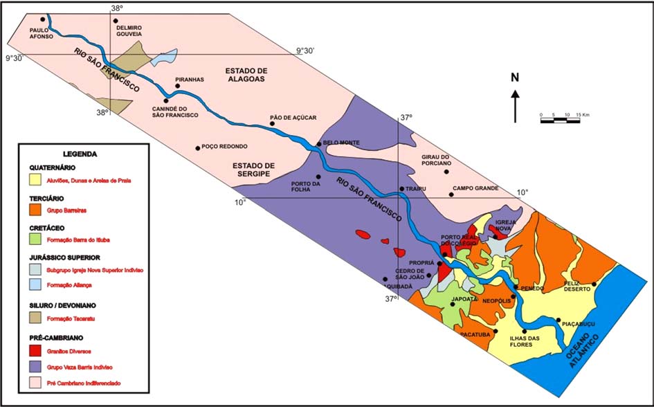
Figure 1. Physiographic subdivisions of the
SÐo Francisco Basin (CODEVASF, 2002)
The main objective of the researches now presented, is to analyze the relationships between
the hydrological and geomorphologic changes caused by the construction and operation of the
SÐo Francisco River Dams Complex and the arising of accelerated marginal erosion processes
in its low course, relating their impacts in the antropic medium, between the city of PropriÃ
and the river mouth.
i
To achieve such objectives, the subproject was
developed in two phases: Phase 1: Analysis of
the historical river evolution and the impacts
generated by the dams on the channel
morphology. Phase 2: Study of the distribution
and causes of the marginal erosion.
The report comprises themes included in the
Subproject 2.4 Phase 1 and Phase 2, focusing
both the detailed study of the marginal erosion
stretch along the Cotinguiba-Pindoba Irrigated
Perimeter, and an including vision, when
emphasizes the morphodynamic behavior of
the SÐo Francisco River low course.
Each group of factors and processes involved
in the marginal erosion phenomenon are
separately analyzed, being them of natural
order or resulted from the impacts produced by
the man, especially, through the construction
and operation of great dams located upstream.
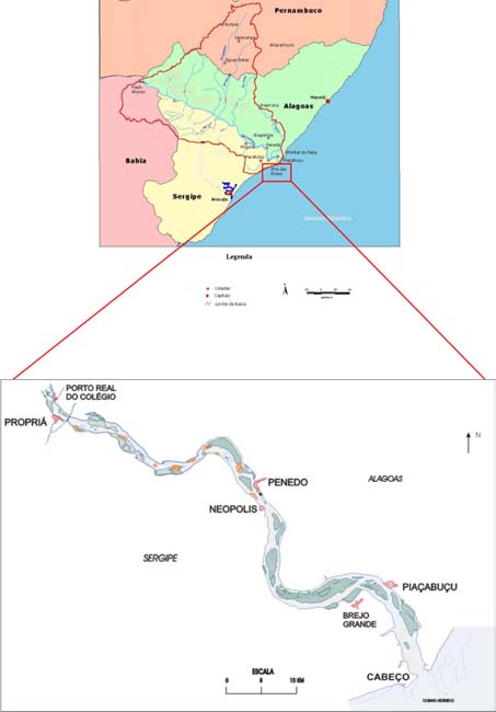
Figure 2. Studied area (blue), limits of the Sub-basin (red line) and a detail of the SÐo
Francisco River low course. Source: CODEVASF, 2002 and Fontes (2002).
Finally, a comparative line is drawn between the hydrogeomorphologic adjustments by whose
the SÐo Francisco River low course is suffering after the changes in the hydrosedimentologic
regime promoted by the dams built upstream and the answer models to the impacts
downstream extracted from national and international study cases of great dams.
1. CHARACTERIZATION OF THE PROBLEM
In the last years, a series of environmental impacts have been reported in the low SÐo
Francisco as a result of successive human interventions in the river, mainly those supposedly
resultant of construction and operation of the Companhia HidroelÕtrica do SÐo Francisco
(CHESF) dams, located upstream. The environmental changes attributed to these dams
initiated in the end of the 70's, after the Sobradinho Dam construction.
In fact, where great dams were built along the river course, as in the SÐo Francisco, deep
alterations are expected, breaking the fluvial system natural dynamic balance, mainly
downstream.
Both spatially and temporally distant from the generated facts and place, the detected
environmental alterations along the SÐo Francisco River low course channel, in its flood plain
and in its mouth, get the attention for its diversity and magnitude.
The alterations in the fluvial regime include, not only the regularization of the river flows but
also, other significant changes in its hydraulic and sedimentologic behavior, especially in the
ii
stretch located between the city of
Proprià and the mouth. Therefore,
deflagrating a series of negative
environmental impacts in the low
SÐo Francisco area ecosystems, in
the seacoast close to the mouth and
in the antropic medium.
The arising of economical and
social problems brought by
environmental impacts produced by
the great dams, assumes more
significant proportions in the low
SÐo Francisco, being probably the
more impacted region in the entire
river course. There are indications
that this region presents the largest
hydro-environmental vulnerability
in the entire SÐo Francisco River Basin in relation to the changes introduced by the
construction and operation of the great dams.
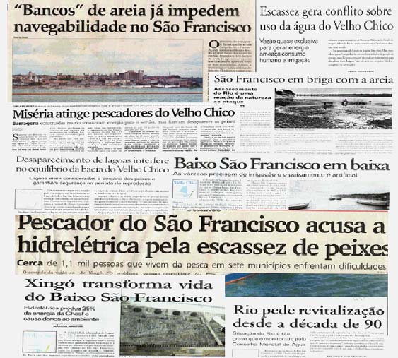
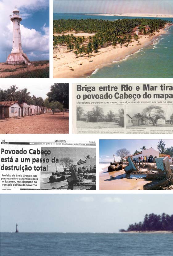
Figure 3. Mosaic with Aracaju newspapers articles (CINFORM, Correio de Sergipe and
Jornal da Cidade) published in 2001 and 2002.
There are great number of technical reports, National Integration Ministry (2000), CPERH
(1997), CONSÆRCIO JAAKKO POYRY-TAHAL (2000) and Academic Studies (Vargas,
1999, Holland, 2000, Fontes, 2002), describing a preoccupying current picture of
environmental fluvial ecosystem degradation in the SÐo Francisco Low Course and their
marginal flooded areas. Those reports emphasize the serious socioeconomic and cultural
consequences brought by the environment alterations.
The major responsibility for these unbalances, are unanimous attributed to the regional
development public politics, and especially, the option for the development model that
prioritizes the use of the river as hydroelectric energy generator and supplier of water for
irrigation, in despite of other uses of water.
Vargas (op. cit.) emphasizes that, from the moment that the natural river cycle was interrupted
by the great dams the man-environment interaction started to change in the area. For instance,
they affected the traditional fishing activity directly, altering the fishery rules, as well as the
utensils and the fishing period, which were daily defined by cosmological forces of the nature
but were abandoned and changed into past stories.
The dams are also pointed by the riverine community as the main responsible for the
environmental changes observed in the last years. These subjects mobilized the Sergipe and
Alagoas society and gained great repercussion in the local and regional press (Figure 3), being
object of countless interviews, lectures and debates about the environmental situation of low
SÐo Francisco.
The multiple demands for the SÐo Francisco River hydrological resources are configured as a
typical development and environment conflict picture by the use of water. The reservoirs
iii
operation, which is centralized in the energy generation and in the supply of water for
irrigation, improved the Northeast development, but also brought a strong environmental and
socioeconomic burden, because this model considered the ecological priorities as marginal.
The use of the SÐo Francisco Basin hydro-energetic potential allowed the Northeast itself and
its industrial park to develop, but in the other hand, brought substantial alterations in the
fluvial regimes and negative impacts in the fluvial ecosystem and in the riverine populations'
life.
1.1. A picture of environmental degradation. After the Dams construction.
The charts 1 and 2 synthesize the more frequently environmental mentioned problems, direct
or indirectly related to the dams upstream river. They were extracted either in the technicians,
riverine population, local society and authorities reports and comments.
Chart 1. Synthesis of the environmental problems more mentioned in the publications in the
low SÐo Francisco as caused by the upstream river dams in the channel area.
1. AREA OF THE CHANNEL
ENVIRONMENTAL AND GEOMORPHOLOGICAL IMPACTS AND OTHER CHANGES IN
THE PHYSICAL ENVIRONMENT
Decrease of the intensity, frequency and, now, absence of floods
- Most of the publications attributes to the Dams the interruption and even definitive elimination of the
floods.
- The riverine population believes that, since 1994 the floods were eliminated by the Xingµ Dam.
Riverbed sediment deposition
- More shallow river (widespread decrease of the river medium depth).
- Appearance of many "croas" (banks of sands).
- Modifications in the morphology of the fluvial riverbed.
- Reduction in the capacity of transport of rude particles.
Proliferation of erosion focuses in the margins
- Accelerated erosion in the margins of the river and islands, with fall of banks and the margins
retrocession.
-
Lateral instability of the SÐo Francisco riverbed.
Decrease of the content of nutrients and fine particles in suspension in the river
-
Water liberated by Xingµ has low load of nutrients in most of the year.
-
Waters before characteristically cloudy, muddy, they became limpid, with low load of sediments in
suspension in most of the year.
Accelerated erosion in the right margin (south) of the mouth
-
Modification in the coastal dynamics.
-
Unbalance among sea and fluvial processes.
-
Deficiency in the contribution of sediments (deficit of contribution of sediments).
-
Move back from the coastal line, by the erosion.
-
Destruction of the CabeÓo village (SE) by the erosion.
iv
CHANGES AND CONSEQUENCES OF THE ALTERATIONS OF THE PHYSICAL MEDIUM
ON THE BIOTIC AND ANTROPIC MEDIUM
Fishes, fish and fishermen
Changes in the fishing calendar
-
In seasonal terms and of more favorable schedules to the fishing.
Changes in the fishing techniques
-
Adaptations to the new conditions of the river and to the changes of the type and amount of fish.
- The development of the macrophyte denominated "hair" is pointed as one of the problems for the
fishing, as the use of nets gets difficult to working and it still serves as favorite habitat of predators as
the "piranha" and the "tucunarÕ".
Changes in the quality of the fish
- Decrease of the weight and length. Pisces and shrimps now fish decreased in weight and length in
relation to the previous situation.
CHANGES AND CONSEQUENCES OF THE ALTERATIONS OF THE PHYSICAL MEDIUM
ON THE BIOTIC AND ANTROPIC MEDIUM
Changes in the amount of fishing resources
-
Decrease in the amount of fish, especially the noblest species.
-
Decrease of the absolute amount of fish and shrimps.
-
Species more sought, as "Surubim" and the "Pitu" shrimp, decreased drastically of amount.
- In the past, Low SF was recognized by the abundant production of fish and crustaceans and as the
area with the largest production in the entire Basin.
Changes in the socioeconomic relationships:
-
Youngsters lost interest for the profession.
-
Drastic decrease of the fishermen incomes.
-
Marginalization of the craft fishing activity, restricting it to a secondary and cheap activity.
-
Distinction between fish farmers and professional craft fishermen.
-
Appearance of some conflicts between fish farmers and fishermen.
Incentive to the predatory fishing and on-exploration
- Intensive use of traps for shrimps in a very superior amount to practiced previously.
- Fishing efforts every time larger to obtain amounts every time minor, to grant a minimum of
remuneration, threats to overcome the ecosystem capacity of recovery. The result also takes to the
reduction of the natural stocks of fish and shrimps.
- The drastic decrease of the amount of fish and shrimps, formerly abundant, motivates the use of
predatory techniques, in the enthusiasm to obtain a larger income of the fishery. Small portion of the
professional craft fishermen appealed for the use of bombs and other predatory techniques.
Changes in the reproductive cycle of the icthyofauna
- Interruption of the "piracema" (fishes upstream migration), in the Xingµ-Paulo Afonso stretch, for the
construction of the Xingµ Dam.
- Absence of fish stairway in the Xingµ Dam, causing interruption of the "piracema".
- Absence of strong streams from the flood cause harms in the biological cycle of most of the species.
- Limpid waters in good part of the year harm the spawning and the protection, which before was
granted to the alevin against the predators.
Changes in the species diversity and the existent ecological communities' structure in the riverbed,
estuary and coastal area
-
Proliferation favoring of some species.
Example: the largest penetration of solar beams in the waters, due to the shortage of sediments in
suspension, favored the proliferation of macrophyte plants, particularly the species denominated by
the riverine as "hair" (Elodea sp).
v
-
Destruction of native habitats
-
Alteration in the biodiversity of the holms previously flooded with SÐo Francisco waters.
Changes of the nutritious content of the river waters and in the coastal area
-
Decrease in the amount of nutritious necessary the maintenance of the biota
Changes in the use of the riverine lands
- Bankrupt in the traditional agriculture based in the periodic floods, with the rice culture in the
marginal ponds and holms.
-
The absence of floods impedes new contributions of nutrients, making the soil fertility falls year after
year.
-
Losses of agricultural areas and engineering works due to the marginal erosion.
Changes in the navigation
-
The changes in the morphology of the riverbed and the decrease of the river depth hinder navigation
excessively, reducing the boats load-displacement and the safety of the fluvial transport.
-
The presence of tree trunks pulled by the margins erosion is an additional risk to the navigation.
-
The loss of the importance of the fluvial transport is not associated to the construction of the Dams.
Changes in the river mouth
-
Destruction of the CabeÓo village for the erosion.
-
Destruction of agricultural areas in the river margins for erosion.
-
Impacts on migratory corridors in the coastal area.
It is important to stand out that most of the related changes in the Charts 1 and 2 were
obtained from the riverine people and researchers' personal observations, what grants their
credibility. However, they can generate, without the necessary proof, mistaken interpretations
and general affirmatives in several cases, mainly in those situations in which different causes
can take to a same environmental result.
An evident example in this sense is the riverbed disseminated widespread sediment deposition
in the entire extension of the low course of the SÐo Francisco River, which was disclosed not
from studies results, but interpreted starting from the observation of many sandy banks
("croas") presence, emerged or shallow in the river.
Among other affirmatives, published without confirmation, there is the wedge saline estuary
inward invasion, the fluvial erosion and the sediment deposition and, they are direct
consequences of margin forest dropping. Just in rare cases, mainly in academic studies, the
observations and interpretations are based on detailed studies or are proven through
quantitative data.
Although the related verifications above can be found in several technical reports and
publications, unanimous in considering them as a consequence of the construction and
operation of the great dams upstream, the great lack of studies proving or quantifying this
cause-effect relationship became evident.
Chart 2. Synthesis of the environmental problems more mentioned in the publications on Low
SÐo Francisco as elapsed by the river bars upstream in the marginal area.
2. MARGINAL AREA (HOLMS FLOODED)
Extinction of the marginal ponds due to the lack of water feeding during the floods.
-
In the inundations the ponds were supplied of waters, sediments and nutritious, fertilizing the soil and
restoring foods for the icthyofauna.
vi
- Holms that didn't receive irrigation projects were abandoned, in terms of its traditional use, by the
total feeding lack of flows of floods.
-
The enriched soils of the holms and ponds were used traditionally for the rice planting.
Impracticability of the traditional agriculture in the ponds and holms
-
The riverine populations, before the Dams construction, used the ebb tide agriculture, in the drought
period, done on the humus left by the river after the floods. Nowadays, those populations depend from
the rain or irrigation for its subsistence. The great majority doesn't have access to the latter.
- The fishing in the ponds, whose waters were dammed by the riverine by the ebb tides occasion,
represented an additional source of income, although it probably harmed the natural cycle of the
fluvial icthyofauna.
Changes in the icthyofauna reproductive cycle
- Interruption of the marginal ponds use, as part of the reproductive cycle, and its condition of
reproductive native species "nurseries".
- The calm and nutrients rich waters favored the feeding and shelter for countless species in the
reproduction period. Traditionally, the fishing was easy and abundant during the whole year and,
particularly in the ebb tide period, after the floods.
1.2. The manifestations of the marginal erosion downstream to Xingµ dam.
Among the current environmental
problems of the SÐo Francisco River
low course, the marginal erosion stands
out for its visibility, width, distribution
and socioeconomic consequences. The
erosion in the of Low SÐo Francisco
margins has been generating a growing
decrease of the production areas,
located in the irrigated perimeters,
carting damages for the economy of the
two involved States (Sergipe and
Alagoas).
While other environmental changes are
processing in a subtle way, the margins
erosion is one of the most visible
manifestations of the fluvial system
dynamics alterations.
Figure 4. Marginal erosion problems. Complaints in the Aracaju newspaper,
Cinform, Correio de Sergipe, in 2001 and 2002.
It is, in the riverine population view, one of the ways found by the river to demonstrate the
gravity of the changes. This geomorphologic phenomenon, for its visibility and
aggressiveness, has been obtaining a great repercussion in the regional press (Figure 4).
The erosion in the SÐo Francisco River low course margins assumed more drastic proportions
in two right margin river stretches, where, coincidentally, are the irrigated perimeters of
Cotinguiba-Pindoba and Betume, both implanted by CODEVASF in the end of the70's. In
these stretches, the margins retrocession destroyed houses; Irrigated Perimeter's engineering
works, highways and it took to agricultural areas losses. Besides, generated significant
additional financial costs to CODEVASF, which was forced to rebuild the protection dikes
vii
against floods that border the irrigated perimeters and to execute works to protect them from
the erosion.
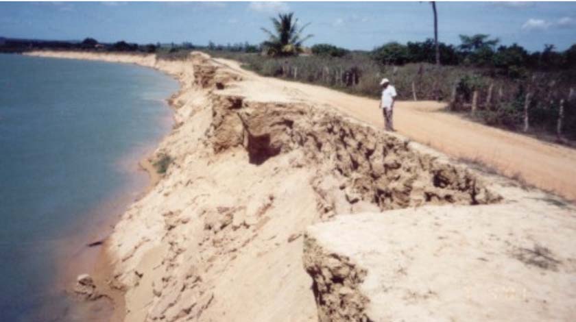
The most dramatic manifestation of the erosive process happened in the mouth area, where
the coastline retrocession took to the CabeÓo village (Sergipe) destruction, located in the
south margin (Figure 5). The material losses were estimated in more than 40 houses, school,
church, and cemetery, besides a great beach area.
Only the light, built in the XIX
century, resisted to the waves and
tides action and stays, still today,
semi-intact and already inside of the
ocean (Figure 5), as an eyewitness of
the erosive events and the old coast
line position. Under a social point of
view, the erosion effects brought
many upset to the town's population
that, after local public government
intervention, the town was moved to a
new place, losing part of their
historical identities.
The CabeÓo village case represents the
environmental degradation state lived
by the river, as the "the river's mouth
works as an indicator of changes
introduced in the hydrographic basin,
being extremely sensitive to the
impacts generated by the upstream
great works, which had modified the
flow regime in the water course and,
consequently, the balance between the
coastal sea processes and the fluvial
ones" (CPERH, 1997).
Figure 5. Photo showing the erosive process evolution and the coastline retrocession
in the CabeÓo village Ù SÐo Francisco's mouth.
1.3. Natural or induced erosion?
The presence of past fluvial sedimentary deposits in the plain and margins of the SÐo
Francisco River attests that lateral changes in the channel position are part of its
environmental dynamics evolution. Changes in the channel position are necessarily
accompanied by the margins erosion, the only way for the fluvial riverbed move sidelong.
viii
Therefore, if the marginal erosion makes part of the geological history of the SÐo Francisco
River low course, why then to detach it now as a recent event, with negative environmental
implications? And why to associate the current manifestations of the erosive process along the
river margins, to the antropic interventions along the hydrographic basin?
It is necessary to stand out that both the natural and antropic made dynamics results in a same
product: erosion in the margins. This fact hinders the analyzing process of causes and imposes
the establishment of an appropriate methodology to the problem's solution.
A historical approach to this matter was sought. The purpose was to discern the differences
between one and the other influences, starting it from the analyzes of the changes in its
hydrological and sedimentologic regime in this river stretch, besides the channel evolution
observation, in cartographic and aerial-photo basis, and in satellites images. There were also
collected information through a series of observations field, as well as the research of the
documents concerning about the erosion problem in this river stretch, and informal interviews
with riverine residents (irrigators, boatmen and fishermen) and CODEVASF technicians that
act or used to act in the area.
One of the most defiant subjects, for those observing the river now, it is to find the answer to
the fact that the accelerated marginal erosion in low SÐo Francisco happens, day by day,
largely in normal conditions, without floods or in episodic and atmospheric events. A margin
retrocession can be noticed after few days, when a point is marked in a certain margin stretch
submitted to the erosion. This is a peculiarity that intrigues the ones that know the
phenomenon.
The acceleration and the spread of the marginal erosion in the low course of SÐo Francisco
River is an indirect consequence of the dams built upstream. In order to obtain a satisfactory
answer to this suspicion, which was brought out for several researchers, environmentalists and
riverine population representatives. This report discusses the intervening factors, the involved
processes and their possible direct and indirect causes.
2. ENVIRONMENTAL CHARACTERIZATION OF THE LOW SûO FRANCISCO
Low SÐo Francisco occupies an area of 30,377 kmý, equivalent to 5% of the total area of the
SÐo Francisco Basin, which corresponds to smallest portion among the four physiographic
subdivisions of the Basin.
The SÐo Francisco River low course is placed in the stretch between Paulo Afonso city, State
of Bahia (BA) and its mouth, completing a total of 265 km in the west-east direction. For
effect of the present report, the low course is approached exclusively in the stretch between
CanindÕ of SÐo Francisco - where it is located the Xingµ Dam - and the SÐo Francisco River
mouth, in the Atlantic Ocean.
The SÐo Francisco River is used in this region for different social and economical purposes,
such as water supplying for urban populations (besides the city of Aracaju and vary other
cities of the State of Sergipe and Alagoas, placed inside or out of the Basin), domestic
effluents dilution, short cycle irrigated agriculture provisioning, fishing, aquiculture,
ecological tourism, navigation and exploration of the hydroelectricity through the Xingµ
Plant, and Hydroelectric Company of SÐo Francisco - CHESF.
ix
The SÐo Francisco low course valley, for its perpendicular configuration in relation to the
coast, crosses several morphoclimatic domains of the area, which presents a perceptible
zoning direction W/E, from the most arid to the humid coastal (Vargas, 1999).
It crosses, in the same way, three great geological morphostructural units (Figure 6):
Precambrian crystalline / meta-sedimentary lands, sedimentary Mesozoic and quaternary
sedimentary lands (Monteiro, 1962, in Vargas, 1999).
Figure 6. Simplified geological map of low SÐo Francisco area. Modified from: Carta
Geolµgica Brasil ao MilionÕsimo, DNPM (1976).
These units correspond, respectively, to the following geomorphologic units: "Sertanejo"
Pediplan, Coastal Boards ("Tabuleiros Costeiros") and Coastal Plain (Figure 7).
The riverbed settles on igneous and metamorphic Precambrian rocks between Paulo Afonso
(BA) and Proprià (SE). Between Paulo Afonso (BA) and PÐo de AÓºcar (AL), the SÐo
Francisco River runs fitting in a canyon and the surrounding relief is a pediplan, "Sertanejo"
Pediplan (Figure 7). In the latter prevails a soft-wavy relief of low hills predominantly on
granitites, with some "inselbergs" standing out in the landscape.
To PÐo de AÓºcar (AL) downstream, the canyon finishes and the valley enlarges as the river
approaches to the coast, but the surrounding relief includes a larger variety of relieves,
including since a plane relief till a strongly wavy. Discerning mainly by the different incision
degrees in the most prevailing schist and gneisses (SUVALE, 1973).
This subunit, also considered as part of "Sertanejo" Pediplan, is characterized by presenting
alignment of subsequent and perpendicular crests and valleys, results of differential
dissection, consuming of bent structures and occasional exhibitions of its schist, quartzites
x
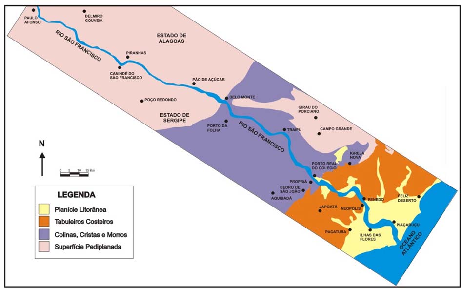
and gneisses bases. The fluvial plain is narrow, enlarging only in the confluences with the
tributaries.
The municipal district of Proprià is positioned in the limit between the arid and the humid,
between the savanna and the mesophyllic forest, between the pediplan and the boards,
between the litholic soils and the podzolic soils, between the Sergipe-Alagoas sedimentary
basin and the Precambrian lands of the Dobramentos Sergipana strip.
Figure 7. Geomorphologic units of Low SÐo Francisco. Modified of DNPM, 1976.
From Proprià (IF) till Neµpolis (SE)/Penedo (AL), the river cuts the morphostructural
sedimentary Mesozoic unit lands and develops a larger fluvial plain. The coastal boards
developed on the Grupo Barreiras tertiary sediments predominantly constitute the surrounding
relief of the valley.
From Neµpolis on, the river cuts quaternary Pleistocene and Holocene lands which grew an
deltaic aspect, formed by alluvial and coastal deposits that constitute the coastal plain (Figure
7). The coastal plain takes place along the Sergipe and Alagoas coast and it constitutes a
monotonous landscape, with a surface approximately plain with waviness created by active
and inactive eolian dunes.
The riverbed is comprised in the SÐo Francisco River geomorphologic unit plain, which
corresponds to the bottom of the river valley. It is an accumulation surface generated by
fluvial processes (CODEVASF, 2000).
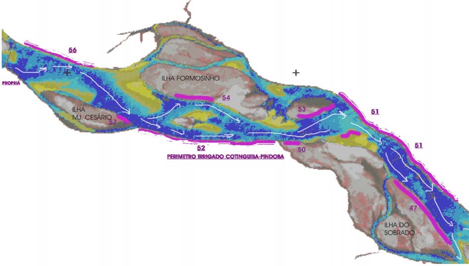
The permanent floods stretches are known as holms and the others constitute the fluvial
terraces. There were identified 145 holms (CODEVASF, 1973), occupying a flooded area of
78,000 ha, 130 of them occupy small areas. Two holms, Marituba (AL) and Betume (SE),
occupy more than half of this area (Figure 8). Other larger holms are Boacica, Cotinguiba,
Itiºba and PropriÃ.
xi
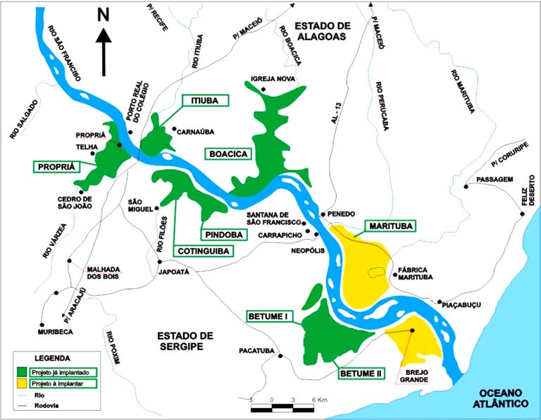
Figure 8. Holms and Irrigated Perimeters of CODEVASF in Low SÐo Francisco.
Source: CODEVASF (1973).
In terms of declivity, the SÐo Francisco's River Low Course presents a small initial stretch,
about 65 km, between Paulo Afonso (BA) and Piranhas (AL), where occurs a declivity in the
order of 115 meters. In its final stretch, from Piranhas to the Mouth, the river travels about
200 km with an average declivity of 0.5 m/km.
About the climate, the low course of the SÐo Francisco River travels initially a semi-arid strip,
which gradually passes to humid sub-humid, starting from Proprià till the mouth. In the part
of the studied basin, between Proprià and the mouth, the annual average temperature
compensated is about 25o C. The hottest month is December, which varies around 26 to 27¤C
and the coldest month is June, which temperatures is around 23¤C.
The annual pluvial precipitation is between 800 and 1,200 mm. The monthly precipitation
average distribution presents a rainier period that goes from March to August, and a less rainy
one, which extends from October to February (SEPLANTEC, 1997).
3. ANALYSIS OF THE HISTORICAL EVOLUTION OF CHANNELÇS
MORPHOLOGY AND THE MARGINAL EROSION IN THE STRETCH OF THE
IRRIGATED COTINGUIBA-PINDOBA PERIMETER
In the last 148 years they were not found evidences of significant changes in the position of
the SÐo Francisco River main curves, at the stretch between Proprià and the mouth. Unlikely
from what it is common to happen in great rivers crossing sedimentary plains in its inferior
course, great and evident lateral changes were not observed in the fluvial bed position and
neither migration of their curves in the mentioned historical period (Figure 9).
xii
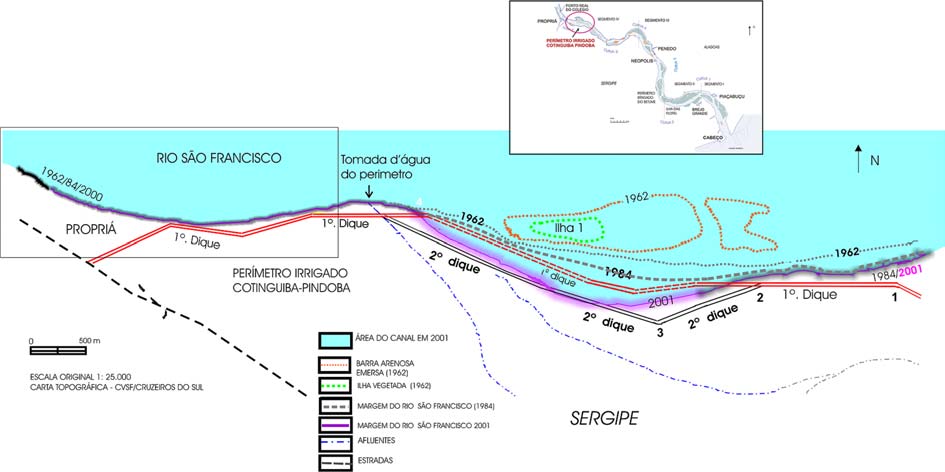
Figure 9. Map presenting successive lines of the SÐo Francisco River margins (1962,
1984 and 2001), reconstituted starting from topographical maps and aerial pictures.
In spite of that, internal changes in the morphology of the riverbed happened and yet, no
significant changes in the external riverbed geometry were noticed.
In the historical analysis of the morphologic changes, in plan, of the fluvial channel it was
evident that the river segment between Proprià and Penedo is characterized by constant
changes in its internal morphodynamic and in the path of the main channel /"talvegue".
(Figure 10).
The historical attendance had showed that in the early 70's, an inversion of the dominant
geological process happened in the river stretch where the Cotinguiba-Pindoba Irrigated
Perimeter is located, in the right margin. Until the 60's the sedimentation prevailed, but
already in the early 70's the place became a stage for the erosive processes performance, not
in a continuous way though, once it was inserted by sediment deposition periods after the
floods.
Concomitantly, a change in the main talveg path happened, from the left margin till the right.
Starting from the big flood of 1979, the main channel/"talvegue" had moved from the
riverbed center and then to the right margin (Sergipana), where it stayed ever since, with a
strong tendency to accentuate its curvature towards the stretch where the Cotinguiba-Pindoba
Irrigated Perimeter is located.
xiii
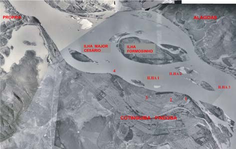
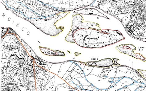
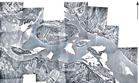
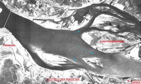
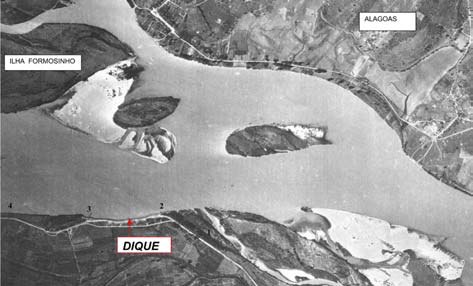
Aerial picture of the Cotinguiba-Pindoba Topographical map (1962) of the Cotinguiba
obtained in 1950, inundation period.
holm (CODEVASF)
Mosaic of 1973's aerial pictures, main flow December 1984 aerial picture. Blue arrows
lines (blue). Notice the formation of new bars indicate interpretation of flux lines to left
in the channel and the erosion of the island 1 sandy formations, PropriÃ-ColÕgio bridge.
located in front of the Cotinguiba margin,
accompanying change in the talveg path.
Assembly of aerial pictures obtained in 2000
January 1988 aerial picture, in inundations
period. Notice the dike's proximity to the
margin.
Figure 10. Comparison of aerial pictures and maps from the Cotinguiba-Pindoba area
in different times
xiv
Therefore, the Irrigated Perimeter Cotinguiba-Pindoba stretch erosive phenomenon beginning
is previous to the Irrigated Perimeter implantation and the Sobradinho Dam construction.
However, it was evident that the erosive process in the right margin became accentuated in
the early 80's, period immediately subsequent to the Sobradinho hydroelectric Power Plant
operation starts. The erosive process became more aggressive in the late 90's, what can be
partly attributed to the channel incapacity to modify and to renew periodically its inner
morphodynamic, absence of annual floods and, also due to the channel necessity to adapt to
the new hydrosedimentologic conditions imposed by the construction and operation of the
great dams upstream.
Considering the eroded strip width in the 1980-2001 period, the river moved forward about
750 meters in the more critical point, being 350 meters corresponding to an island previously
existent in the place and 400 meters to the retrocession from the river margin, what results in
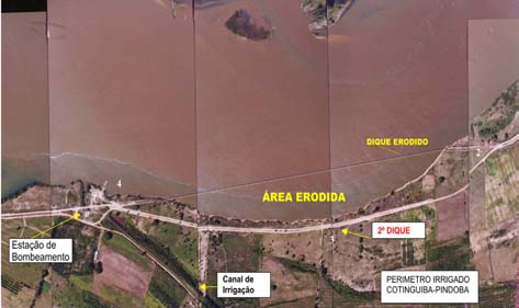
a medium rate of around 22.0 meters/year (Figure 11).
Apparently this retrocession didn't happen in a uniform way. Besides having provoked the
partial destruction of the 1st and the 2nd protection floods dikes of the Cotinguiba-Pindoba
Irrigated Perimeter. Nowadays, about 2,000 meters along the margin continue suffering
intense fluvial erosion.
The civil engineering solutions used by CODEVASF to contain the progress of the erosion -
always adopted in emergency character and with high cost - partially failed, probably due to
the lack of previous studies objecting an understanding of the fluvial dynamics behavior and
the knowledge of the factors and involved processes, made worse by the absence of necessary
data of hydrosedimentologic and geomorphologic monitoring.
xv
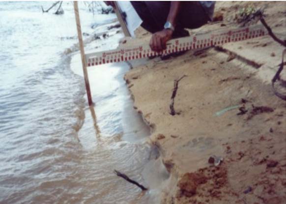
Figure 11. The margin line retrocession, destroying the land strip previously existent
between the highway and the river margin. Picture a) obtained in 24/5/1999 and b) in
8/11/1999. Pictures: Casado (2000).
4. QUANTIFICATION OF THE COTINGUIBA PINDOBA IRRIGATED
PERIMETER MARGINAL EROSION
The margin stretch monitoring corresponding to the Cotinguiba-Pindoba Irrigated Perimeter,
from the February 1999 to October 2001 period (33 months) which resulted in accumulated
marginal erosion rates (margin retrocession), differing in agreement with the monitored
section: in the Section A it was of 15.37 m, in the Section B, 66.46 m and in the Section C of
17.15 m. (Figure 12)
The B section, where occurred the largest erosion rate (monthly average of 2.0 meters and
annual average of 24 meters), it is also characterized for to presence of the largest percentages
of sandy material (95.31%) and smaller percentages of clay and silt (0.97%) in the
composition of the bank base layers, what grants its smaller cohesion and, under this aspect,
larger susceptibility to the erosion.
The differences in the marginal erosion rates distribution, which vary from a point to another
in the margin, are partly attributed to the changes in the lithological characteristics of the bank
and its height, and partly to the interrelations with the channel dynamics.
xvi
The data suggest that the largest
margin retrocession rates are
related with larger percentages
of sandy material and smaller
silt and clay percentages in the
particle gradation composition
of the bank layers. The bank
height is also an important
factor - the largest heights
correspond to the largest
erosion rates.
The marginal erosion also has
an important temporal
distribution. It is not continuous
and is linked to the climatic
events magnitude, mainly the
tides and hydrological events
intensity, as the small variations
in the regulated flow and the
consequent variations of the
river level and flow speed.
Those, in association to the
characteristics in each point of
the bank, made the erosive rates went larger in certain months of the year.
Figure 12. Localization of erosion process monitoring sections. Obtained erosion rates:
Section A (8.30 m/year), Section B (47.30 m/year). Source: CASADO (2002)
The erosive process magnitude is significant in this margin stretch, with high annual erosion
rates, which provokes economical, social and ecological negative impacts to the area. Besides
destruction of civil engineering works built in the SÐo Francisco margins and loss of great
agricultural soil volume.
Along the monitoring period, methodological problems were lived with the pins method use,
caused by the extraordinary magnitude of the erosive process. The fast margin lines
retrocession, in few months, made impracticable the use of the pins in the retrocession
measurement. It was verified that the pins only play effective part in the measurement when
the marginal erosion rates are inferior to 0.8 m/month.
The total volume of eroded material, February 1999 to October 2001, considering only the 3
monitored Sections influence areas, was 10,107 m°, corresponding to a loss of 38,664 mý of
arable area in the Cotinguiba-Pindoba Irrigated Perimeter (Chart 3).
xvii
Chart 3. Volume of eroded material. Three sections studies from February 1999 to
January 2000 period.
Medium
Lateral extension of
Margin
Volume of eroded material
Section
height of the
the monitored
retrocession
(m° - cubic meters)
bank (meters)
section (meters)
(meters)
A 5.21
12.0
7.30
456.40
B 6.36
12.0
33.30
2,541.46
C 3.91
12.0
2.45
114.95
A consequent decrease of the water table hinders the navigation and reduces the possible
boats load-displacement, what harms the locomotion and access to services for the riverine
cities population. Besides it threats the fluvial transport safety. In shallow stretches an easy
unbalanced proliferation of algae (macrophyte) is observed, due to larger possibility of solar
light reach the river bottom.
The macrophyte, denominated as "hair" or "bush" by the fishermen, inhibit the use of
instruments like the net and the "tarrafa", what has been committing the sustenance of a great
portion of the population living in the riverine areas, surviving of fishing.
5. GEOTECHNICAL BEHAVIOR OF THE MARGINAL SLOPES IN THE
COTINGUIBA PINDOBA IRRIGATED PERIMETER MARGINS
Geotechnical behavior relevant results of the marginal slopes and of the water table in the
Cotinguiba-Pindoba Irrigated Perimeter stretch.
Flow and level variations in the river interfere excessively in the local aquifer provoking its
elevation or lowering. These quota variations in the studied river area are conditioned to the
ascents and daily descents provoked by the tides in the estuary and to the flotation in the flows
liberated by the Xingµ Hydroelectric Power Plant.
In the monitored period (January 2002 to February 2002) the normal hydraulic flow of the
local underground water happened in the river margin sense. The water table level rises in a
0.1744 m/meter ratio, as it draws away from the margin.
However, when the river level elevates (which happens daily, caused either by the tide or by
the Xingµ Hydroelectric Power Plant operation) the flux is inverted, coming from the river to
the margin. In this case, the relationship between the elevation of the river level and the
groundwater level, obeys the 1:0.6861 proportion, another words, each 1 meter elevation in
the river quota corresponds to a 0.6861m elevation in the water table level.
Only in the Section C, no relationship was observed among those variables, in spite of the
attempt of establishing a correlation between the river and the underground water levels, since
the quotas of the underground water level stayed unaffected during the studied period. This
can be attributed to a lesser permeability of the slope base material in section C, which is
predominantly silt-loamy, compared to the other sections. It also explains why the erosive
process is lesser aggressive in section C.
The normal direction of the hydraulic flux, from the margin to the river, gets the attention for
its contribution to the slope base washout process. The water percolating the interior slope
xviii
towards to the river exerts, by its viscosity, a pressure on the underground particles. This
pressure acts in the flux direction and tends to provoke a movement or leaching of the finest
particles to the slope base. As consequence of that process, the sandy layer slope base has
been submitted to an unbalance situation. Besides, the underground water flux makes the
slope base saturated, leaving it more susceptive to the waves washout action (Figure 13).
Figure 13. Schematic representation of the main mechanisms of marginal slopes
destabilization studied in the SÐo Francisco River low course.
In the slopes stability analysis, the sections present differentiated safety factors (SF). In
natural conditions with no antropic intervention ("retaludamento"), none of the sections have
showed to be stable. Just the section C presented a Safety Factor (SF)=0.975 close to the
limit-balance SF=1. The slopes instability should be considered as directly related to the bank
layers particle size gradation characteristics. In the unconsolidated sandy lands, the instability
degree will be larger than in more cohesive soils.
The lack of vegetation in the slope surface and the water table lower than natural conditions,
also makes the appearance of another erosion predisposing factor. The direct incidence of the
solar beams on the representative sandy material particles, which constitutes the slope surface;
causes losses in its natural humidity. The drying brings as consequence the losses of apparent
cohesion provoking the particles separation and favoring its removal by the action of
gravitational force.
The lack of floods, imposed by the river flow control of the great dams in the last 10 years,
has also implied in the water table lowering in the corresponding year period (December to
May). This means that in practically half of the year, the water table level stays below the
natural level, which, among other implications, means loss of margin sands cohesion,
favoring the gravitational mass movements occurrence.
6. CHARACTERIZATION AND DISTRIBUTION OF THE MARGINAL EROSION
IN THE SûO FRANCISCO RIVER LOW COURSE
In 2001, there were identified and registered, 72 focuses of accelerated marginal erosion in
the strip comprised between the PÐo de AÓºcar (AL) and the SÐo Francisco River mouth. In
the stretch object of this study, comprised between Proprià and the mouth, there were
registered 57 focuses of marginal erosion (Figure 14). Upstream, between Proprià (SE) and
PÐo de AÓºcar (AL), there were identified the others 15 focuses. In spite of the marginal
erosion focuses occurrence in both margins, the largest amount of them and the ones with
larger magnitude are located in the "Sergipana" margin.
xix
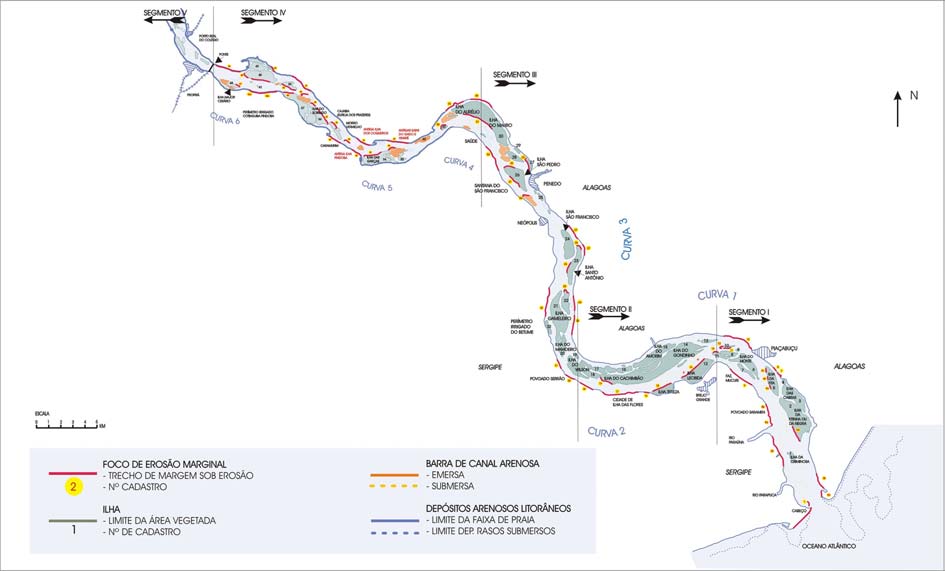
Figure 14. SÐo Francisco River low course map, between Proprià and the mouth,
divided into identified geomorphologic segments and features.
In the river right margin (Sergipe), between Proprià and the mouth, the sum of the stretches
lengths under erosion results in a total extension of 29.90 km. This means that 39.9% of the
"Sergipana" margin is now suffering erosion. In the Alagoas side, the marginal erosion
reaches a smaller extension, in the order of 17.8 km, what corresponds to 22.5% of the left
margin line length. In absolute terms, the erosion in the right margin exceeds those in the left
in 12.1 km, in other words, a difference of 68% between them.
The marginal erosion is not restricted to the main riverbed margins. The margins of the
islands and of the "croas" (sandy bars emerged) located in the middle of the river, also present
stretches submitted to the erosion in process, making a total of 10.5 kilometers.
6.1. Types of fluvial margins and patterns of the margins submitted to the erosion
In general the SÐo Francisco River stretch between Proprià and its mouth, presents three
classes of margins: margins in erosion, margins in accretion and stable margins. Margins in
erosion were defined as those being now submitted to the significant performance of
accelerated erosive processes, they present constant retrocession and they form banks with
almost vertical faces (also referred as marginal slopes or "barrancas").
The margins under erosion were classified in six different types (A, B, C, D, E and F) based
in their physical characteristics and in their relative positions to the talveg and channel
geometry, presenting different responses in relation to the erosive processes performance.
The Type A margins (Pontal da Barra Type) are constituted by sands of existing eolian dunes.
They occur only in the river mouth left margin.
xx
The Type B (Saramen Type) are sandy margins, of smooth profile, where a fluvial beach strip
grows, limited by an erosive nature small bank, with restricted distribution to the river lower
segments, between the mouth and the proximities of the Ilha das Flores city.
The Type C Margins (Fazenda Mucuri Type) have a similar space distribution and they are
also low margins, although essentially constituted by clays rich in vegetables remains.
The Type D Margins (Dique Type) correspond to those river stretches where the margin
retrocession reached the floods protection dikes of the CODEVASF Irrigated Perimeters or
where rock blocks were put ("enrocamento") for the margin protection against the marginal
erosion.
The Type E Margins (Betume Type) are characterized by mixed constitution (clays, silts and
sands interstratified), of high and medium height, with no beach strip. They are prevalent in
the stretch comprised between the Ilha das Flores and Penedo, which are positioned close to
the "talvegue".
The Type F Margins (Type Cotinguiba-Pindoba) are essentially formed by medially to highly
no-cohesive sands. They are characterized for their usual position in the "talvegue"/main
channel curves, in the points where these make an inflection towards the margin. Type
Cotinguiba-Pindoba's are distributed between Proprià and Neopµlis, where are concentrated
the most actives and extensive focuses of marginal erosion (Figure 15 and Picture 1).
Figure 15. Vertical stratigraphic profile Picture 1. Margin base of the main riverbed
of the no-cohesive margin type,
constituted by sands of fluvial origin. Notice
produced by the waves.
the Irrigated Perimeter Cotinguiba-Pindoba
washout.
7. THE MARGINAL EROSION FACTORS AND CAUSES ANALYSIS
7.1 geomorphologic and hydraulic factors and processes related to the fluvial stream
xxi
The channel geometry affects a lot of the marginal erosion causing forces. The fluvial channel
main flux lines action, which follows the talveg lines (Figure 16), is very important in the
marginal erosion space distribution.
Figure 16. Image obtained from the geoprocessing of the 1991 SPOT satellite image. The
more blue tones indicate deeper waters and they allow the talveg plan view. Notice the
narrow relationship between the talveg (white line) and the stretches under accelerated
erosion (lilac lines).
The erosive focuses mapping and the satellite images processing had showed a narrow
relationship between most of them and the stretches where the talveg was located adherent to
the margin. Most of the cases are related to the main channel, but there are cases where the
channel bifurcates and the erosion happens in the two river margins, one in the main and
another in a secondary channel.
An important conclusion was made. There are not a direct relationship between the erosive
focuses and the riverbed external curves, in the same hydrodynamic models of the sinuous
channel pattern. In the low course of the SÐo Francisco River the relationship between the
marginal erosion developments is intimately related to the talveg path, where it concentrates
the largest speed of the aqueous flux.
In the river curves, the main flux evidently suffers an inflection towards the external bank
(concave, in relation to an observer located inside the river), the same happening to the river
talveg (line of larger depth), although with a stronger angle (Figure 17). The stream exerts a
shearing stress pressure on the margins and the exerted attractive forces lift and drag the
margin constituent particles. A margin stretch in this situation has a high probability of
erosion, which magnitude will depend on the flux velocity, on the velocity distribution pattern
and on the margin material characteristics.
xxii
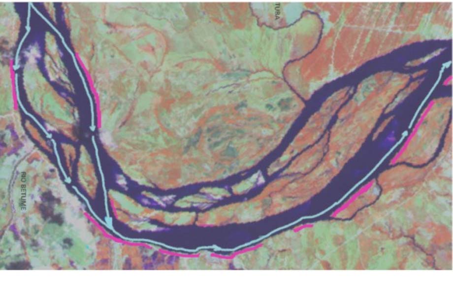
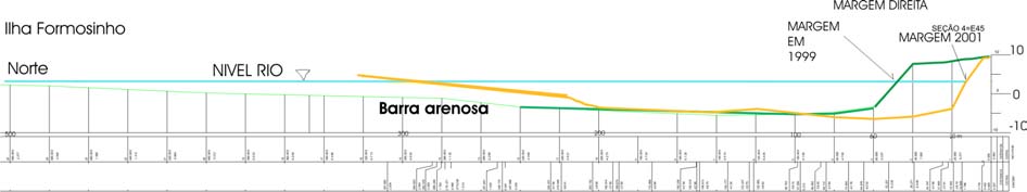
Figure 17. Interpretation of the main talveg (pale blue line) incising on the external
margin river curve and its relationship with the margins under erosion (lilac lines).
Segment II, Curve 2. LandSat 1990 Satellite Image.
It is verified, in the other hand, that in smoothly sinuous to straight river stretches erosive
focuses are also found. It was evident that these cases were also related to the talveg
proximity to the margin. The expressive presence of channel bars and of plant-covered islands
in the SÐo Francisco River, also promotes constant subdivisions in the river flux, creating
secondary channels, which reunite downstream.
These constant channel bifurcations make the talveg sometimes move toward a margin and
other times to the other, without necessarily being associated with a river curve. In general it
describes a strong inflection towards to the margin, what raise the fluvial stream erosive
effects potential that has its velocity drastically increased in the stretch, compared to their
previous values. The sinuous talveg path reinforces the conclusion that it is the main
controller of the erosive focuses distribution.
It was proven through expedite bathymetric surveys that in most of the margins stretches in
erosion process, the talveg is located a few meters (usually less than 10 meters) from the
margin (Figure 18).
Figure 18. Transverse schematic channel profile based on bathymetric survey made by CODEVASF in
November 1999 (green line) and in June 2001 (orange line). The blue line corresponds to the regularized river
level. The margin of the Cotinguiba-Pindoba Irrigated Perimeter.
xxiii
The positions of the main and secondary river channels are modified along the time as part of
the fluvial dynamics and, as a consequence, the same happens with the talveg line. Either in
natural fluvial system or in those controlled by man, the talveg changes as a function of the
discharge alterations, the load of sediments or as a consequence of erosions and depositions
occurred in immediately previous moments.
It is clearly noticed that in some stretches of the talveg line path occurred great changes in its
position. Therefore, margins stretches previously distant from the talveg, suffering discrete or
no erosive process, started to present intense and accelerated erosions due to the talveg
position inversion. The most notable case is the one corresponding to the Cotinguiba-Pindoba
Irrigated Perimeter.
Other changes even more recent in the talveg path were found in other river stretches
submitted to the fluvial erosion. These changes can be considered as one of the immediate
causes for the accelerated erosive processes currently arising in these places.
7.2. Morphologic characteristics of the margins and their relationships with the erosion
High margins compared to the medium and low margins, when being submitted to the same
forces, factors and processes, present a larger retrocession effective rate. The height favors the
arising and the frequency of mass movements controlled by the gravitational action and it can
favor the underground water participation in the erosive process, mainly in those constituted
by sands or interstratified (sands and clays).
The higher margins in the studied stretch are located exactly in the more critical erosive
focuses: Cotinguiba-Pindoba (ME-52) and Betume-Povoado CerrÐo (ME 20 and 22), both
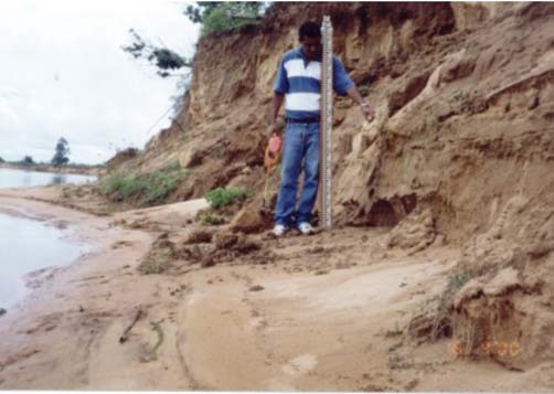
between 5 and 8 meters of height and constituted by interstratified sands with clays (Photo 2).
Photo 2. General view of the Cotinguiba-Pindoba Irrigated Perimeter edge (ME-52). In
the first plan, remaining portions of the protection floods levee, which locally
constitutes the superior part of the bank, having a more straight behavior.
Notice the formation of the fringe or "skirt" formed by deposits of grains flux.
xxiv
The lower edges are mostly constituted by clay layers, and their heights vary between 0.5 and
1 meter (in relation to the river level, in 2001). In relation to the height, the edges space
distribution shows that usually, the higher and medium ones occur in the estuary more distant
segments (III and IV) and the lower ones in the stretches closer to the estuary (II and I).
The fluvial beaches, when
present, tend to be of small width
and its formation is related to at
least two distinct geneses. The
edges in accretion, or those
already stabilized, or the emersed
sandy bars edges, are formed in
the cost of particles brought by
the stream.
In the stretches where talveg
meets adherent to the edge, it
does not have development of
beach band or it is incipient, with
inferior maximum width of 1,0
Photo 3. Narrow fluvial beach, in a stretch under
meter (Photo 3). The proper
erosion. The humid sand band is an
inexistence of the beach band is
evidence of the recent river level
an indicative of the proximity of
descending, in the zone of inter-tides.
the talveg and the intense action
of the fluvial stream. A good part
of the stretches of edges under erosion does not possess beaches, characteristic that favors the
direct attack of the waves in the base of the abrupt declivity.
In the edges stretches where the beaches are well developed they help in the stabilization of
those under erosion, when limiting the waves range (Fernandez, op. cit) and favoring the
dissipation of its energy.
The edges under intense erosion with beach strips are included in two distinct contexts:
narrow beach strips associated to high edges and wide beaches. In the former, they are
intimately associated to the talveg proximity in relation to the edges and the conjugated
fluvial stream and waves daily action. In the latter, they are far from the talveg and associated
only to the action of waves occurred in the episodically higher tides.
The bathymetric surveys realized in the stretches without beach or with narrow beach and
where the talveg is found adjacent to the edges, showed the presence of a narrow submerged
band, approximately flat and shallow, that extends till the main channel edges. This band was
denominated as abrasion platform.
This band remains covered by the water, even in the low tide corresponding periods and
represents the area where the directly removed material from the bank or from the beach by
the waves. This material is initially accumulated and later rebuilt and redistributed by the
fluvial streams. The abrasion platform contributes to the absorption of the waves energy
largest part, which occurs in the edges direction.
xxv
7.3. Lithological, geotechnical and pedological factors, for the edges and associated
erosive processes
The lithology and the grain size distribution of the edges constituent material exert an
important role in its degree of stability and function as facilitator or inhibiting factor to the
advance of the marginal erosion. The edge resistance to the erosion is directly related to its
lithologic characteristics. According to the constituent material, the edges in erosion are
grouped and classified, following its degree of cohesion, which states the greater or minor
stability of the marginal slope and strength to particles removal by the erosion.
The edges formed essentially for cohesive sediments are most resistant to the erosion.
However, when they suffer washout and/or they are saturated, mass movements occur
frequently, as fall of blocks and landslides. The erosive action on these edges, therefore, is
only effective when they suffer the corrosive action from the fluvial stream (provoking the
washout) or the direct shock of the waves in the ascents of the tides.
The edges had been individualized as edges of Type C (Fazenda Mucuri Type) and are
spatially distributed only in the river mouth neighborhood. By its estuary position, they are
highly submitted to the tides action, whose amplitude is enough to reach the top of the edges
due its small heights.
Edges formed essentially for non-cohesive sediments are those classified as Type A (Pontal
da Barra Type), Type B (Saramen Type) and Type F (Cotinguiba-Pindoba Type), being
constituted of essentially sandy lithology. They are highly susceptible to the erosion, which
depends on the association with other factors and erosive processes. They are found in the
talveg edges lines, in the islands and in the emerged bars.
In terms of spatial distribution, this type of edge occurs in all the studied stretch, but with
larger concentration in segment IV, between Cotinguiba-Pindoba and Cajaiba (erosive focus
ME 46 to 52), where edges had been individualized with of Type F (Cotinguiba-Pindoba
Type), constituted of fine to medium sands and friable to very friable, practically without
cement or siltic-clay matrix, what in a large extent explains the vulnerability and easiness with
that the erosion advances over them, when associate to other factors. The constituent material
removal occurs mainly in the base of the bank, grain by grain, by both stream flow (corrosion)
action and the waves action (Photo 4).
This type of edge is also highly susceptible to the masses movements (Photo 5), for the action
of gravity, due to low particles cohesion, once ruptured the initial condition of stability. The
two gravitational processes involved in these episodes are the flux of grains, in the bank
intermediate part and the fall of blocks, in the superior part. For the sandy layers located in
the bank base, the initial disruption of the steady condition takes place by the washout caused
by both directly action of the stream flow and the waves action. For the superior siltic-clay
layer (in which the soil is developed), it takes place by the washout caused by the underlying
sands removal.
xxvi
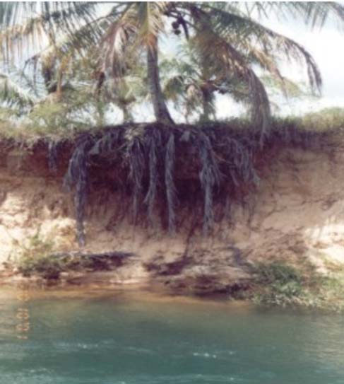
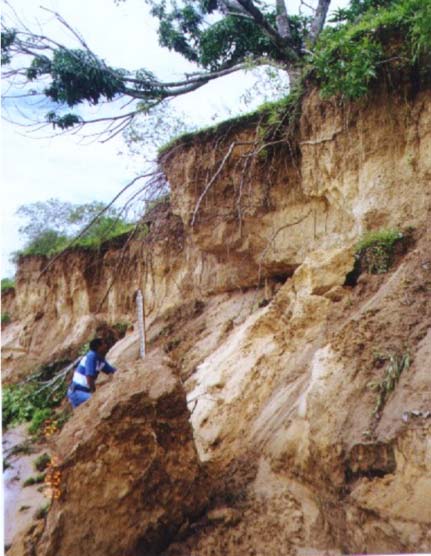
Photo 4. Photo evidencing the performance Photo 5. Conjugated action of
of the fluvial erosion by corrosion,
gravitational processes: flux of
below the ground roots level. In
grains and fall of blocks
this place the talveg is found close
to the edge (Focus Me-26).
The sands constituting the central and thicker portion of the edges, mainly in the case of the
Cotinguiba-Pindoba, are characteristically very friable, non-cohesives, and they move
downward the bank through the mechanism of flux of grains. The easy occurrence of this type
of mass movement is not only attributed to the geotechnical characteristics of sands, but also
to the lowering of the water table, diminishing much their humidity content, and,
consequently, its degree of stability. Previously to the reduction of the floods frequency,
theoretically this process should have a lesser magnitude and frequency in relation to those
occurring in the current days.
Edges of mixing constitution (Edge Type E - Betume) are made of mixing constitution,
consisting in intercalated layers (interstratified) of materials with various particle size
distribution (clays, silts and sands), permeability and cohesion and are products deposited in
previous phases of the river, reflecting the changes in the outflow conditions, transport and
deposition of sediments by the river. This type of edge is vulnerable to the masses movements
in the bank slope, but in an inferior degree compared to the totally non-cohesive edges.
In a mixing edge, the sands, silts and clays layers structure have influence in favoring or
resisting to the erosion process. Depending on its position, the layer can be accurately located
in the river fluctuation interval or found being submitted to the mainstream flow action. In
these cases the susceptibility is greater when the layer is sandy and, in contrast, the resistance
to the erosion is bigger when deals with cohesive sediments, which also, can protect partially
the adjacent sandy layers.
In the other hand, the river level variations can make that, in some stages, distinct resistance
layers being reached by the flow and/or by the waves erosive action. Moreover, the relative
xxvii
position between cohesive and non-cohesive layers can favor the arising of masses
movements, as the marginal erosion removes the particles.
Edges formed by engineering construction (edges Type D - Levee) correspond to the
protection levees built along the SÐo Francisco river right edge with the objective of
protecting the irrigated perimeters against the floods and, which had been reached in some
stretches due to the edge line retrocession (ME-52, ME-18).
Currently, in these stretches they constitute the proper edge of the river. The response to the
erosive processes performance is similar to those with mixed constitution edges. The
presence of silte and clay in the matrix of these sandy formations provide larger geotechnical
stability for this pattern of edge, diminishing the occurrence of masses movements, in relation
to the not cohesive edges.
7.4. Factors related to the estuarine dynamics and its reflexes in the marginal erosion
The level of the SÐo Francisco River is affected daily by the oceanic tides, as the ascent of the
sea level provokes the natural slide bars in the river flux. The rising and lowering in the fresh
water level in the river, in two daily cycles of high and low tide, exerts an important role
promoting the marginal fluvial erosion. The tide influence is perceived until the
neighborhoods of the city of Proprià (SE), distant 75 km from the estuary.
A hypothesis is suggested. The upstream tide influence increased after the outflows
regularization in the river, not only in linear terms, reaching points a little more upstream, but
also and mainly, in a temporal way, therefore extending its action to the months when it
previously had little influence. The regularization of the river provoked the summer high
outflows frequency and magnitude reduction, and also, the momentary absence of them since
1992, creating conditions for the advancing of the upstream tides influence.
Additionally, the river level remains more or less constant during all the year, increasing the
tide action potential on the edge. This possibility has repercussions in the marginal erosion
phenomenon, where the tides action is an important element in its evolution.
The variations in the oceanic tides amplitude, caused by astronomical events (tides of syzygy
and tides of quadrature) or episodic climatic events (strong storms and winds) play an
important role modifying the normal values of oscillation of the tides in the estuary, which
reflects in terms of increasing potential for its erosive effects in the fluvial canal.
This means that, in the inferior river stretch, in the periods of the exceptionally high tides of
syzygy, the tide maximum level rise between 50 and 70 cm above to the maximum reached in
the quadrature tides. It also means that the waves produced during the tide ascent will reach
the banks, situated more distant from the water lines (by beach band presence) or more high
banks levels (when there is no beach or only a narrow band of it).
In this way, the erosive attack in certain focus of erosion present in segments I and II, as ME-
5/Saramen (Photo 6) and ME-16/Ilha Teresa, which is more efficient when occurs
simultaneously with the effect of the meteorological bonanza tides or equinox, can be
explained.
xxviii
Photo 6. Marginal banks only reached during the exceptionally high tides. The
displayed coconut palms roots mark the previous edge line position. Povoado
Saramen (ME 5).
The tide level ascent, followed by the waves production, is responsible for several erosive
effects and the production of various forms in the edges, whether alone or acting together with
the fluvial fluxes. Its performance is registered under the inter-tide band form in the fluvial
beaches, by the reentrances in the banks base and by the production of micro scarps in the
beach band or in the base of the bank slope, in a constant process of collapsing and
retrocession.
The processes that give origin to these forms are of two natures: removal (it produces micro
scarps and reentrances) and redistribution (band of beach and marks of "deixa"). For the
marginal erosion phenomenon it is of interest, over all, the former.
The edges material removal has, besides its direct erosive action, an indirect consequence,
fundamental to keep the continuity of the evolution retrocession process in the edges: the
material withdrawal that was accumulated in the bank base proceeding from the bank high
parts, thus preventing that the edge comes to reach its equilibrium profile. If such thing
happens, could lead to the edge retrocession process interruption, until another agent (in that
case, the channel flux) provokes some change.
A detailed analysis of the removal process shows two performance forms:
a) In the first one, the direct removal of constituent individual particles of clays or sands,
promotes the washout of the bank base, and, along the time, it creates instability in the
superior part of the bank, which pulls down or slides, in forms of bigger blocks. These,
when falling in the waves zone of action, will enter again in the erosive cycle, being
dismembered and removed by the waves;
b) In the second, the removal occurs by the micro scarps formation in the beach band sands
or in sands accumulated in the bank base as resulted from mass movements downward
the slope. Step by step, the micro scarps retrocede and allow the new accumulated sand
removal in the bank base.
xxix
7.5. Performance of the winds in the edges erosion
The winds act in an indirect form promoting the marginal erosion. They are in part
responsible for the waves formation and these acts directly in the edges particle removal.
The direct wind erosion on the edges sandy material is little significant in terms of
retrocession rate, although has been observed, mainly in the banks that constitute the
islands edges and bars between Proprià and PÐo de AÓºcar.
The constant waves action produced by the winds is only intensified when associated to the
meteorological tides Ù at storm occasion followed by strong winds Ù or even in the
coincidence of syzygy tides and strong winds, when they can exert a more decisive role in the
marginal erosion.
A secondary form of the winds performance is the direct action on the friable sandy sediments
displayed in the emersed bars edges top (not vegetated), as well as in the face of banks with
lack of vegetal covering, due to a recent erosion. In the field observations, it was verified that
when the wind blows directly on the edge, constituted by friable and dried sands, promotes
the transport of grains clouds and the formation of deflation surfaces and eolian
accumulations (small dunes).
The lowering of the water table provoked by the regularization of the river level and the
absence of high outflows (with rise of the river level), results in lesser humidity in the
constituent sands of the essentially sandy edges, with reduction of its cohesion, favoring the
action of the wind in its displayed surface. In relation to the edges erosion, the result of the
erosive winds action is insignificant into the bank's face.
7.6. Natural hydrologic regime of the SÐo Francisco River, its natural seasonality and
the role of floods in the fluvial dynamics
Approximately 80% of the SÐo Francisco River low course total waters come from the sub-
basins of the high SÐo Francisco. The participation of the affluent sub-basins in the low SÐo
Francisco, in its majority formed by intermittent rivers, normally does not reach the value of
5 % that was even proportionally very lesser than before 1993, when in the floods periods, the
outflows reached between 4,000 and 12,000 m°/s.
However, some of the bigger repercussion floods in the low SÐo Francisco were formed due
to the conjunction of the high outflows proceeding from the high SÐo Francisco, with
abnormal pluviometric precipitation in the sub-medium tributaries, as the case of the great
flood of April 1985 (CEEIVASF, 1985).
The interannual variations graphics evidence a pattern characterized for the extreme outflows
variability, but with a seasonal occurrence, in practically every year in the period from 1926
to 1976, with monthly averages peaks over 4,000 m°/s, between the months of December
from one year to March of the following year.
The annual floods used to carry, either a great volume of material in suspension and nutrients
for the icthyofauna, and sandy particles as bottom load. In this way, they played an important
role in the replacement of the material previously removed by the fluvial erosion. In the other
hand, the strong rapids provoked the remobilization of the sandy material previously
deposited in the streambed.
xxx
In this stage occurred the biggest sandy bars mobility, especially those previously found
emersed, promoting many changes in the talveg geometry and consequently, in the locations
directly subjected to the direct and intense action of the channel flux. Therefore, an annual
renewal occurred, irregularly distributed along the years, as the characteristics and intensities
of the floods were alternated.
Since 1994, conditions of this nature have not been observed in the low SÐo Francisco.
Therefore, it allows to discard them as promoters of the present acellerated erosive phase.
The last flood occurred in 1992. It is important to stand out, that the occurrence of future
floods is not discarded and thus would be able to interfere with the fluvial dynamics and with
the associated erosive processes.
7.7. Antropic factors related to the dams construction and operation and to the new
hydro-sedimentologic regime
Among the diverse uses of the upstream waters in the SÐo Francisco River, which affects
more directly its low course it is, no doubt, the one related to the electric power generation.
Not only for the necessity of dam construction and great reservoirs formation, but also for its
operation form, what leads to alterations in the hydroelectric power plants effluent fluxes
pattern and characteristics.
Five aspects of these alterations exert direct or indirect influence on the SÐo Francisco River
low course fluvial hydrodynamics and, consequently on the marginal erosion: the drastic
reduction of the solid load; the rise of the minimum outflows; the maintenance of
approximately constant outflows during long periods (regularization); the alteration of the
seasonality and the control of the floods.
Analyzing the influence exerted by the barrages into the hydric and sedimentologic regime of
the SÐo Francisco River, three periods were considered:
The first period (1978-1987) corresponds to the phase when the Sobradinho dam influence
over all the extension of the downstream river, was initiated on the hydrosedimentologic
regime. Especially the low SÐo Francisco, which was still affected for the eventual
contributions by the tributaries, situated in the sub-medium SÐo Francisco, despite the
existence of the Moxotµ and Paulo Afonso dams. Sobradinho represents a mark in the
hydrologic and sedimentologic history of the SÐo Francisco and represents also the most
significant intervention and control of the man on those conditions.
The second period (1988-93), corresponds to the phase when the Sobradinho and Itaparica
participation were added, besides Paulo Afonso IV and Moxotµ (the latter, a reservoir with
weekly regularization), extending the control on the outflows and the sediments retention in
the Sobradinho downstream stretch. For the low SÐo Francisco this phase is covered with
importance, therefore, besides meaning a bigger reduction in the supply of sediments, it
represents a bigger control on the high outflows and eventual floods, whose genesis is related
to the sub-medium SÐo Francisco tributaries contribution. Regarding about the sedimentary
and nutrients load, the absence of unloaders in the bottom disables even a partial replacement,
besides the successive retention promoted by each dam.
The third period (1994-2001), corresponds to the phase under direct influence of the Xingµ
UHE. By its position and influence, Xingµ can be considered as an artificial spring for the
xxxi
river in the stretch extending from the dam to the Estuary, what rigorously cannot be
considered as a natural river anymore. Even being Xingµ a "fio d'Ãgua" ("water line") power
plant, it represents a significant mark in the artificiality and control of the
hydrosedimentologic conditions in the stretch extended till the estuary.
First, for holding back a small contribution of alluvial sediments in the stretch from Paulo
Afonso to Xingµ, what represents the final link in the blocking chain of the almost totality of
particles proceeding from upstream. Second, because its operation produces artificial
fluctuations in the daily outflows that play an important role in the present river dynamics.
In practical terms, for the stretch in the low SÐo Francisco between Xingµ and the estuary,
that hydroelectric plant practically controls all the river flow, as the contribution from
downstream tributaries is minimum. Despite this, the real control is in Sobradinho, therefore,
the Xingµ operation is total dependent on the water releases from the Sobradinho
hydroelectric plant.
Even though the dams system operation is not totally independent of the natural climatic and
hydrologic conditions fluctuations, they already present a high degree of control and high
level of regulation in the periods when these conditions do not exceed the normal limits. It is
convenient to stand out that this affirmation is strengthened by the lowermost contribution in
terms of liquids and solids discharges that the SÐo Francisco river receives from its tributaries,
as much of the right and left edges, located in the basin stretch downstream Xingµ.
7.8. Interannual outflows variation after 1978: the alterations in the river natural
seasonality and the floods control and the consequences in the erosion process
The interannual variations observation of the monthly average outflows in the low SÐo
Francisco fluviometric stations, allows evidencing that in the immediately posterior period to
the construction of Sobradinho dam (1978-1987) occurred a rise in the minimum outflows,
but still remained the strong annual outflow peaks, characteristic of summers. Although the
great Sobradinho regularization capacity, the floods continued to occur, reaching average
outflows in the order of 6,000 m°/s, practically every year in the period.
In fact, the floods frequency in the low SÐo Francisco were substantially reduced after 1987-
1888, time coincident with the construction of the Itaparica dam. The Itaparica dam possesses
a small capacity for regularization (variation of 5.00 meters in the water level), playing an
important role in the retention of the outflows produced in the sub-medium SÐo Francisco,
downstream Sobradinho, which were cyclically, the responsible for the floods potential
increasing, like the one of 1985.
Since 1988, only one flood occurred, in 1992, when the average outflow reached 10,000 m°/s,
and a small event occurred in the following year, reaching approximately 5,000 m°/s.
The period after-construction of Xingµ (1994-2001) was marked by the total absence of
floods or even high outflows peaks. This fact led to the false conclusion by several
technicians and riverine population that no more floods would occur in the low SÐo Francisco,
due to the outflows control. Inclusively, there is a mistaken relationship between the apparent
disappearance of floods and the Xingµ dam construction. In fact, a temporal coincidence
between the two facts exists, but Xingµ is not responsible for the eventual floods contention,
according to what was already mentioned.
xxxii
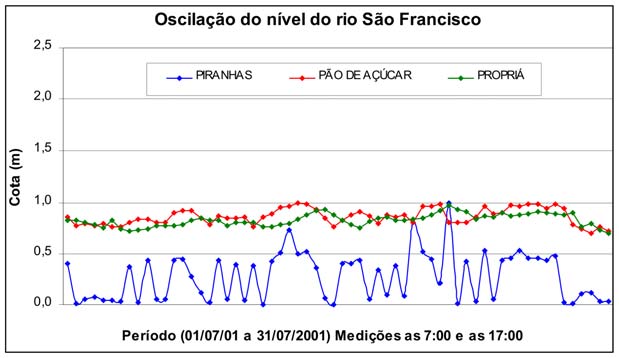
In the other hand, although is occurring a period of lesser pluviometric precipitation since
1993, there is not a great climatic/pluviometric change (Oliveira, 2000) in the basin source
that point to the impossibility of the production, in the future, of great volumes of water
proceeding from rains (inclusively those with return period superior to 10 years), and
overcoming the Sobradinho dam volume capacity, what makes necessary the increase in the
effluent outflows. Depending on the involved water volume, such increase would configure
as a low SÐo Francisco flood event.
About the annual seasonal variations, it is verified that in the last 10 years, the regularization
made the monthly average outflows to stay, in most part of the time, below or next to 2,000
m°/s, which corresponds approximately to the minimum monthly outflows average in the low
outflows period. Thus eliminating the annual seasonality and stop obeying the natural
calendar.
A good aspect to be detached in the low SÐo Francisco marginal erosion study, after the
construction of the cascade of dams: the long duration in the regularized outflow implies in
the river level permanence in a determined value during a very long period, in average
relatively higher levels compared to its previous conditions.
The relative flux stability has some implications in the destabilization of edges constituted by
sediments. Some authors affirm that the duration of a particular discharge is always more
important than its magnitude or the occurrence of flood outflows, except in the case of very
large flows.
It should be noticed that, in the relations with marginal slopes, the possible results coming
from the river level maintenance, in a determined level, during a long time period. At last, for
a complexity of factors, it is supposed that hardly the level of regularity and constancy that is
observed today would be found. The natural regime previously allowed the proper fluvial
environment to find new forms of equilibrium and interaction with the limits in the channel,
which not necessarily resulted in persistent and sharp marginal erosions, as the ones observed
in the last decades.
Other implications are derived
from the main flows positions,
and as consequence, the
positions that the respective
talveg occupy in topographic
maps. It is part of the river
natural dynamics the
modifications in the talveg
position, after the great floods.
These changes in the talveg
line can have some
implications, but it is
convenient to point out that it
Figure 19. Oscillations of the river level in the period
probably avoided, in many
from 07/01/2001 to 07/31/2001
cases, that a line with bigger
flux velocity remained in the same position during several followed years, once the opening
of new trajectories were frequent, what caused the abandonment of places submitted to the
erosion.
xxxiii
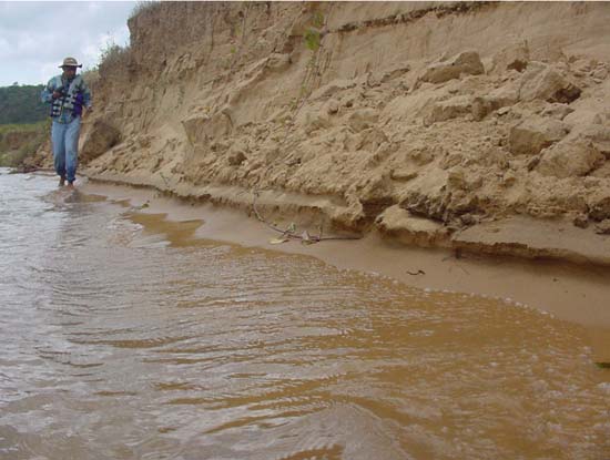
The permanence of the main line flux incidence in a determined edge stretch submitted to the
erosion and the consequent rate of the edge retrocession summation along the years, can result
in a more expressive value than would be expected in a natural picture. This phenomenon
was particularly observed in the band corresponding to the Cotinguiba-Pindoba Irrigated
Perimeter.
It is evident that this context does not apply to all situations. Sometimes occurs exactly the
opposite: in some river stretches small talveg trajectory present changes were identified as
consequence of the recent sandy bars migration, and sediment deposition provoked by the
sediments remobilization in the channel and the removed materials from the edges by the
erosion. This is a clear signal of the non-equilibrium state, which this river segment is
currently passing.
This means that the changes in the talveg positions continue to occur, even so in a lesser
rhythm, stimulated not for the great outflows, but for an effective outflow that makes possible
the deep load (sands) transport, with the consequent migration of small sub-aqueous dunes
and sandy bars in the canal stream bed. These unstable forms are currently in constant
displacement.
In the current conditions the formed bars remain always submerged (except in exceptional
episodes, as the one which resulted in the rationing in the electric power production, 2001),
while those that were formed in a previous condition with higher water level in the river
(floods), today remain emersed but inactives, changing themselves into true fluvial terraces or
islands, being gradually colonized by the vegetation.
7.9. How the artificial oscillations influence the marginal erosion
The daily and monthly fluctuations in the river level after the entrance in operation of the
hydroelectric power plants are felt with larger intensity in the stretch of the river between the
UHE Xingµ and Proprià (Photo 7).
The analyzed data allow showing that the water levels in the SÐo Francisco River, mainly
between Xingµ and PropriÃ, are strongly influenced by the operation rules in the UHE Xingµ
and promote daily oscillations, with amplitude varying from 20 - 60 cm (Figure 19).
In this stretch of the river, the daily
oscillation in the river level provokes
the rise of the water table level,
which associated to the action of the
waves produced by the winds,
promotes the removal of constituent
sandy particles in the sedimentary
edges and produces a micro scarp in
the base of the slope.
This action is important in the
disaggregating of the pulled down
blocks existing in the slope base and
in the removal of its constituent
particles, favoring the erosive cycle
restarting in the bank and, it is an
Photo 7. The photo registers the action of the waves,
important contributing factor for the
during artificial rising in the river level. SÐo Francisco
River edge, close to Gararu (09/13/2001).
xxxiv
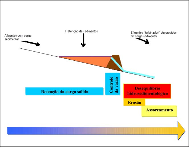
waves action. In the absence of this oscillation in the river level the waves would have its
vertical band of action largely reduced.
In the river stretch downstream PropriÃ, the river level fluctuations occur as a function of the
association between the artificial oscillations and the natural tides, which occasionally can
have added their effects, when occurs the coincidence in their respective rising peaks.
Between Neopµlis/Penedo and the estuary, the normal fluctuations influence in the
regularized outflow are practically imperceptible, due to the larger influence and the larger
amplitude reached by the natural tides.
7.10. Retention of the sediments in the dams and the alterations in the sedimentary
downstream transport
About the bottom load, the small contribution coming from the stretch between the Paulo
Afonso and Xingµ dams are deposited in the portion upstream the reservoir, not having
possibility to enter in the turbines water inlet in the Xingµ plant, situated at 138.0 meters
height. The only possibility in changing this picture, mainly in relation to the suspended load,
is the occurrence of episodes with high outflows from exceptional rains occurring in the high,
medium or sub-medium SÐo Francisco, implying in a drastic reduction in the normal
permanence time of the water in the reservoir.
Among the several resultant impacts from the construction of great barrages (dams) in a river,
the retention in the reservoir of great part of the sediments proceeding from upstream,
substantially modifies the characteristics in the effluent fluxes from the barrage and interferes
with the river stretch dynamics located downstream the barrage (Figure 20).
Figure 20. Simplified scheme of the role exerted by the Xingµ dam in the solid load
retention.
In the specific SÐo Francisco River case, a large amount of the solid load remains retained in
Sobradinho and in the cascade of the barrages downstream. The barrage of Xingµ represents
the final link in the retention chain of sediments proceeding from upstream. Downstream
xxxv
Xingµ the excessively limpid water and the measurements done during the environmental
monitoring program for the plant (CHESF, 1997) indicate an almost total retention of the load
in suspension (Chart 4).
Chart 4. Alterations in the total sediments load carried annually in the SÐo Francisco
River low course
PERIOD PRE-BARRAGE OF SOBRADINHO
PûO DE AúÖCAR (1)
1966 Ù1968
12 (x 106 ton. / year)
PERIOD POS-BARRAGE OF SOBRADINHO
RIVER MOUTH (2)
1983
6 (x 106 ton. / year)
PERIOD POS-BARRAGE OF XINGÆ
PROPRIê (3)
2000
0.466 (x 106 ton. / year)
(2) Millliman (1983) and (3) PROJETO GEF SûO FRANCISCO/UFAL
Source: (1) OEA/PLANVASF (1986). Modified from Oliveira (2001).
Comparing the current data with those gotten in previous years, a notable reduction in the
carried load is verified. Therefore, these values represent only 3.8% of the total solid load
carried before the upstream barrages implantation (12 x 106 tons per year), and 6.8% of the
solid load carried after the barrage of Sobradinho implantation, and yet before the
construction of Itaparica and Xingµ dams.
As the solid particles are almost totally retained in the upstream reservoirs, a question is
presented: from where comes the current sedimentary load carried by the river? Possibly this
small production is due to the material removed by the erosion from the edges of the main
channel in the river, from the edges of islands and emersed bars, from the erosion of the
proper riverbed and, in small scale, from the soil erosion in the sub-basins affluents.
The edges erosion contributions were remarked by Casado (2000). Considering the existence
of more than seventy erosive marginal focuses in the river stretch between Xingµ and the
estuary, it is possible to have an idea about how large is the total volume removed from the
edges. Posterior studies could be able to calculate the total volume eroded in the last years, by
means of aerial and satellite images study.
About the channel responses to the reduction in the solid load contribution, the arising of
erosive processes and sediment deposition in the long river stretch, located downstream the
Xingµ dam, are evidences about the complex readjustment in the canal morphology in search
of a new dynamic equilibrium.
7.11. Role exerted by the vegetal covering
The deforestations cause harm, in part, to the stability of their edges, but they do not exert a
direct role in what is related to the marginal erosive process dissemination. The causes of the
erosion in the SÐo Francisco River low course, are not related to the deforestation and yet to
the alterations in the present behavior of the fluvial and estuarine dynamics. In most of the
cases, they do not depend on the existence of the edges vegetal covering.
xxxvi
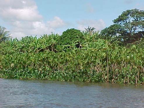
The vegetation covering the marginal bank face or base (in the river level) plays an important
role in the edge protection only, when the channel/talveg larger velocity line is not close to the
edge or when the action of the waves provoked by the exceptional tides are not relevant, or
even when the action of the artificial fluctuation in the river level promoted by the dams
operation is not intense.
Even when the erosion is installed due to the action of these agents, the vegetal protection has
the merit in delaying the erosive action, but only in its preparatory stage or in the opening of
one initial erosive focus. Another words, the lack of vegetation, in the contrary, constitutes a
facilitator factor for the fast advance in the erosive processes.
It is point out that in the case of the not cohesive edges, the exposition of the sand, subjects it
to a faster erosion advance, not only due to the direct action of the river waters, but also for
the deflagration of gravitational processes. Thus, while the vegetal covering resists, it is
inhibiting the edges erosion.
In this region, the erosion provoked by the runoff is not the responsible for the edges erosion.
Thus, the margin bush (top of the edge) although it helps to protect the soil from pluvial
erosion and facilitate the infiltration of the water in the ground, it does not avoid the fluvial
erosion, once it is installed in function of the fluvial estuarine dynamics, being, in reality,
another victim from that phenomena.
In relation to the importance in
maintaining the margin bush, it
is distinguished among the
reasons to keep it, the fact that it
supplies food and shade for the
fishing man and fishes, being
this function more relevant
considering the lack of nutrients
in the limpid river waters.
The landscaping aspect also
should be remembered,
therefore, the improvement of
the landscape surge as a
motivation more to keep it, as it
stimulates the sprouting and
development of the ecological
Photo 8. Steady edge with development of anhinga
tourism in the region (Photo 8).
and ferryman. Edge next to the Ilha das
Flores.
The recomposition of the margin bush, moreover, could help in the soil protection, reduction
in the surface runoff and increasing the infiltration of pluvial waters to the water table. An
ample program of recovery for the margin bush and its conservation, in case that it comes to
be executed in the region, would also contribute to the environmental education and the
change in the behavior of the persons living in the riverine and rural landowners, stimulating
all of them to give a better treatment to the river.
xxxvii
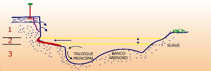
The revegetation of the stretches affected by the erosion will have to be preceded by the
application of procedures that guarantee the containment of the erosion and the stabilization
of the edges in relation to the fluvial dynamics. But, once the edge is stabilized it is
fundamental its revegetation as a form of protection against the action of the waves and the
bank collapsing (gravitational action).
8. SYNTHESIS OF THE DYNAMICS AND EVOLUTION OF THE EROSIVE
MARGINAL PROCESSES
In the major part of the stretches with edges under erosion, it is difficult to dissociate the
action of the waves, from the action of the tides (both related with the oscillation of the river
level) and from the direct action of the fluvial stream flow, as these processes act
concomitantly and/or in a complementary form and the resultant product is the same, that is,
the erosion and, therefore, the withdraw and retrocession in the edges lines.
The three distinct natures of erosive processes acting together to promote the erosion in the
SÐo Francisco river low course edges are: a) related to the canal hydrodynamics, b) related to
the dynamics in the estuary and the artificial oscillations of the river level and c) related to the
geotechnical behavior in the bank (marginal slope). They act respectively in three positions,
in relation to the water surface: below the river level (sub-aqueous), at the river level and
above the water surface (sub aerial) (Figure 21).
Figure 21. Synthesis of the performance of the erosive processes sets
The first set of processes is directly related to the canal hydraulic geometry and with the direct
action of the fluvial stream flow, and it is present through the particle withdrawal by the flux
(corrosion), by the pressure exerted against the walls of the external side in the talveg curves
and by the production of transversal secondary fluxes in the direction to the edge under
erosion.
The second is related with the dynamics of the estuary and the interaction with the oscillations
in the river level produced artificially by the operation of Xingµ Hydroelectric Power Plant.
The dynamics of the estuary is responsible for the production of waves during the daily cycles
of ascent of the tides, which promote the washout, and the withdrawal of the materials in the
base of the banks (Figure 22).
xxxviii
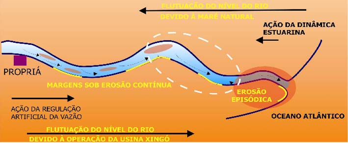
Figure 22. Environmental dynamics, which relate the sets of erosive processes: fluvial
and estuarine.
These waves act at the same time when the waves are produced by the wind. The tides of
syzygy, equinox and the meteorological ones, when raising the river level, make possible that
the erosion comes to reach higher levels in the bank (for times inciding on levels less
cohesives, and therefore, more susceptibles to the erosion) and edges that normally are distant
from the water line, that is, with a wide beach band between the erosive bank and the river
(Saramen Edges type).
Concomitantly to these natural fluctuations in the river level, the artificial oscillations (daily,
weekly, monthly and annual) produced by the operation of the hydroelectric power plants are
added, which are responsible for the action of the waves associated to the ascent of the level
and the consequent variations in the water table that contribute to facilitate the erosion in the
base of the bank.
And the third, consisting in gravitational movements in the banks, occurs with the indirect
participation from the river fresh water, that is responsible for the initial washout stage and
destabilization. In high edges (Edges Cotinguiba-Pindoba type) and with differences of
geotechnical behavior among the non-cohesive levels (friable sands) and semi-cohesive (silts)
the withdraw retrocession of the edges gains a proper dynamic, without the participation of
the river water, during one determined stage in the erosive cycle.
The associated performance of these three sets of processes is responsible for the more
effective erosion rates, if the other susceptibility conditions to erosion were attended The
typical case is the stretch located in the right edge in the Cotinguiba-Pindoba Irrigated
Perimeter, where it reaches the maximum efficiency in the process and velocity of edge
retrocession by erosion due to a coincidence of predisposing factors.
This model does not apply in the case of Type A edges (Pontal da Barra) and the B
(Saramen); therefore, the erosion in these cases is not associated with the action of the stream
flow (sub-aqueous). It occurs in the level of the inter-tides, and only for occasion of the
exceptional high tides, by the direct action of the waves. The erosion in the base of the sandy
and non-cohesive banks provokes gravitational movements, as fall of small blocks and sandy
grains flux, resulting in their retrocession and with the exposition of roots and the falling
trees.
xxxix
8.1. Synthesis in relation to the role exerted by the river level fluctuation and the
gravitational movements in the erosive cycle
The action of the waves promotes initially the washout in the base of the bank. While
producing reentrances, provoke the instability of the superior part of the bank. In function of
the condition of the created instability, mass movements occur with certain frequency, under
the form of blocks collapsing or, eventually, landslides.
The moved material is accumulated in the base of the bank where it is subject to saturation of
the pores for the water due to the ascent of the river level and starts to suffer the direct erosive
action from the waves. When falling in the zone of the wave's action, the material will be
removed from the base in the bank and carried by secondary streams by the fluvial channel
main stream.
This action is facilitated by the saturated sands presence, that suffer successive collapsing,
with the fall of small sandy blocks, what results in the formation of micro scarps in the base of
the bank/edge at each ascent of the river level (either due to natural tide or artificial oscillation
due to the Xingµ Plant operation).
This conjugated action of these processes generally results in the formation of a
steep and vertical profile, into the bank. With the continuous collapsing and
landsliding the trend is to increase during a certain time to the amount of
material in the base of the bank, forming a species of "fringe" or "talus" well
visible, altering the transversal profile, which starts to present a certain
convexity. With the continuity of the wave's action and the occurrence of
gravitational fluxes, the profile returns to be in vertical position completing the
cycle.
Thus, this removal plays an important role for the continuity of the edges retrocession
evolution process, while preventing the edge to reaches an equilibrium profile. If such thing
did not happen, it could interrupt the process of the edge retrocession until another event
provoked the retaken of the erosive cycle.
The action of the gravitational fluxes is more efficient in the non-cohesive (sandy) and higher
edges. Occasionally, the occurrence of a layer of cohesive behavior (siltic-sandy) in the
superior portion, contributes to speed up the process of the edge retrocession and the profile
verticality. When the immediately underlying material to this layer is sandy and non-
cohesive, friable, constantly it is removed through the deflagration of grains fluxes.
The removal of the material from the base of the superior layer provokes its destabilization,
generating the opening of tension cracks that provoke the fall of blocks. These blocks, some
containing portions of soil, grassy and, for times, trees, when they reach the base of the bank
they start to suffer the action from the river water, initially with the pores saturation during the
ascent of the water level and the impact of the associated waves.
8.2. Synthesis about the role exerted by the action of the stream flow in the edges erosion
evolution
The continuous sub-aqueous work of particles removal by the mainstream flow, whose
trajectory coincides with the talveg, is, in last instance, the great responsible for the edge lines
xl
retrocession. Without this removal it would not have continuity in the process, therefore, the
trend would be the bank reaching an equilibrium profile, stabilizing the edge.
The removed material is, in part, redeposited immediately downstream, promoting the
accumulation of sandy sediments in the bed of the channel, forming new submerged sandy
banks. The formation and continuous migration of new submerged sandy banks/bars,
occupying several times the major part of the channel, provoking difficulties to the
navigation. This fact was particularly observed in the case of the Cotinguiba-Pindoba stretch.
8.3. Type of erosion environmental dynamic controller and its influence in the
temporality of the marginal erosion
The sets of the resultant erosive processes from the action of the water (in the inter-tides and
sub-aqueous zone) are directly conditioned or to the fluvial or to the estuarine dynamic. The
first one acts in the upstream-downstream direction and the second in the inverse direction,
that is, from downstream (mouth of the river/ocean) to upstream.
Two patterns of edges had been identified in relation to the form of temporal performance of
the dominant processes and that they are related to the environmental dynamics that promote
them:
In the edges under continuous erosion the main control of the erosion is the channel dynamic,
the dominant process is the stream flow action (it reaches the edges of the types, A, B, C, D
and E), translated by the presence of the talveg adjacently to the edge. The other factors exert,
however, a basic auxiliar role, therefore, they are the immediate and effective retrocession
agents and withdrawal of material from the edges. The erosion in these edges occurs in a
continuous form, daily, and it is strongly influenced by the action of waves in the interval of
the river level fluctuation. This fluctuation can have two origins: a natural one related to the
estuary dynamic (reflected from the tides) and another artificial, promoted by the operation of
the Xingµ Plant.
In the edges under episodic erosion, the erosion only occurs occasionally, being subjected to
the erosion promoted by the waves only for occasion of episodic events as exceptionally high
tides of syzygy, of equinox and meteorological tides (it reaches the edges of types B and E,
distributed in the river segment between the Ilha das Flores and the mouth of the river). The
renewal of the erosive cycle occurs only in these occasions.
8.4. Evolution cycle of the edges under continuous erosion
The detailed observation of edges under continuous erosion that were in different stage
evolution in relation to the responses to the erosive processes allowed to reconstitute the
following evolution sequence: a) Preparatory stage; b) Initial erosive stage; c) Stage of active
erosion; d) Stage of temporary stabilization; e) Stage of the cycle renewal.
In the preparatory stage, the retrocession of the edge still does not occur, but it is noted a
small bare place in the vegetation that covers the base and the face of the edge, resulted from
its withdrawal by the action of the stream flow.
The initial erosive stage involves the formation of an initial erosion focus, located between
portions with remainders of the margin vegetation. This behavior is related to the secondary
xli
stream formation generated from the incidence of wave fronts in direction to the edge and by
the approach from the principal stream/talveg in direction to the edge.
The stage of active erosion is many times marked initially by a sharp basal washout in the
marginal bank directly by the action of the fluvial stream flow, associated with the waves
action. Slowly, the basal washout is less sharp due to accumulation of material collapsed from
the base that, when giving origin to a narrow beach band, modifies the form of erosion
performance. This starts to occur mainly for the spreading and shock of the waves during the
ascent of the river level on the collapsed material present in the base of the bank, despite the
erosion by the stream flow continuing to occur in a sub-aqueous form, now, a little more
distant from the marginal slope/bank.
The stage of temporary stabilization occurs when the high accumulation of material
proceeding from the highest parts of the bank results in a smooth profile and a condition of
temporary stability. Despite this, remains the slow and continuous daily work of particle
removal promoted by the waves and secondary associated streams.
The stage of the cycle renovation occurs from the retaken of the vertical form profile in the
bank, after the removal of the accumulated material collapsed in the base.
9. COMPARTIMENTATION OF THE FLUVIAL SYSTEM AND ITS INFLUENCE
IN THE CANAL MORFO-DYNAMIC ADJUSTMENTS, IN RESPONSE TO THE
ALTERATIONS IN THE HYDRO SEDIMENTOLOGIC REGIME
An including vision such from the spatial as the temporal view, it is necessary, thus the
morpho-sedimentary responses are not occurring in a linear form along the channel length
downstream Xingµ. It was concluded that these responses depend on the morpho-structural
conditionant and the geologic history, which conditioned the geologic-geomorphologic
evolution of the fluvial and the littoral system.
It is exactly the lack of this historical perspective about the erosion and sedimentation
processes that has led to the spreading of precipitated conclusions about the loss of
equilibrium in the fluvial systems. The categorical observations that "the river is in sediment
deposition phase", on the other hand, "disequilibrated because causes erosion in its edges",
for another, do not take into account the forms of propagation of the adjustments produced by
the antrophic impact in the morphologic variables as well as in the biological ones.
Linear responses are typical of the "atualistico" (modern) reasoning where the river responds
linearly to an antropic action. The elaboration of a model for the low SÐo Francisco had as
premise that a system of considerable proportions as this offers morpho-hydraulic complex
responses to the regulations of its sedimentary load and fluxes regime produced by man
It is concluded that the low SÐo Francisco River downstream Xingµ is characterized by a
morpho-sedimentary compartmentation controlled evolution, being able to be divided in five
geomorphologic compartments (Figure 23), defined by lithologic, topographical and structural
controls.
Compartment I extends from Xingµ dam to some kilometers downstream to Belo Monte. The
remarkable characteristic of this compartment is that the SÐo Francisco River is incased in a
canyon (Photo 9) that it is developed, in turn, incased in a pediplan surface (sertanejo
xlii
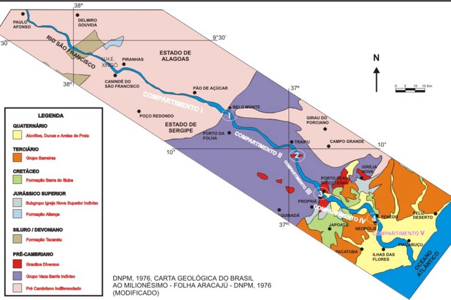
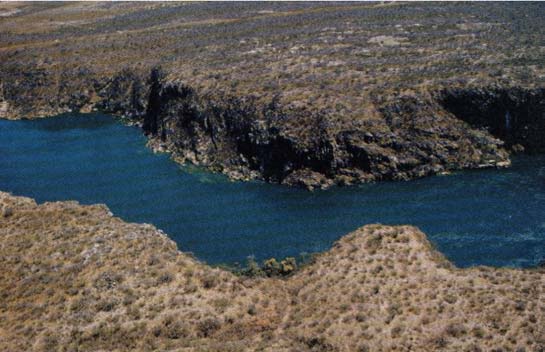
pediplan), and with substratum formed by Precambrian igneous rocks. This compartment
basically acts as a sediments corridor of not being registered fluvial depositional forms of
importance
Figure 23. Geomorphologic Compartmentalization of the Low SÐo Francisco
Compartment III develops from the
node of Lagoa do Monte to Porto Real
do ColÕgio/PropriÃ, where it finds the
contact with sedimentary Cretaceous
rocks of the Sedimentary Basin of
Sergipe and Alagoas. The channel
pattern in this compartment is slightly
sinuous and with interlaced canal
(braided) with sandy islands and bars.
In general the river presents low
coefficient of interlacement, with a
main channel and one or two
secondary around the main islands.
Photo 9. Canyon in the SÐo Francisco in
This segment does not present a well-
compartment I.
developed alluvial plain, even so exists
small-accreted areas to the edges.
In compartment II the SÐo Francisco River is developed incased in a surface with low
desiccated plateaus, forming a relief with mounts, on metamorphic rocks of the band of
"dobramentos Sergipana" of age Precambrian, extending from Belo Monte to node Lagoa do
Monte. The fluvial deposits formed by the channel are rare, basically annexed lateral sandy
bars to the edges.
xliii
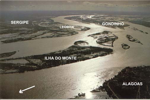
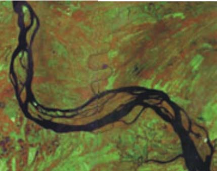
Compartment III develops from the node of Lagoa do Monte to Porto Real do
ColÕgio/PropriÃ, where it finds the contact with sedimentary Cretaceous rocks of the
Sedimentary Basin of Sergipe and Alagoas. The channel pattern in this compartment is
slightly sinuous and with interlaced channel (braided) with sandy islands and bars. In general
the river presents low coefficient of interlacement, with a main channel and one or two
secondary around the main islands. This segment does not present a well-developed alluvial
plain, even so exists small-accreted areas to the edges.
Compartment IV is developed from Porto Real do ColÕgio/Proprià to Penedo/Neopµlis and
cuts mainly the coastal boards area formed on the tertiary sedimentary rocks of the Barreiras
Formation and the Cretaceous in the Penedo Formation.
From PropriÃ, the SÐo Francisco River cuts more soft rocks presenting less incased and
developing an alluvial plain well wider than in the previous compartments. Probably along
the geologic history of the river, this compartment functioned as zone of accumulation of
alluvial sediments proceeding from upstream, probably in result of a relative channel des-
confining and reduction of the gradient/velocity. In this sector, the channel presents with a
interlaced multi-channel pattern (Figure 10) and develops a more complex model than the
previous one. A larger density of islands in relation to the previous characterizes this
compartment.
Figure 24. Geomorphologic Compartment V: a) LandSat image stabilized and
vegetated islands; b) Pattern anastomosed visualized by occasion of the
flooding period.
Compartment V extends along the fluvial-coastal plain from the node of Penedo/Neopµlis to
the estuary. Downstream this point, the river develops an alluvial plain incased on
Pleistocene and Holocene littoral sediments. The channel is characterized by assuming an
anastomosed pattern with great steady islands formed by fine materials (silt and clay) (Figure
24). The vegetation stabilizes the islands. Narrow channels running among the islands, as
well as "paranÃs" (sinuous secondary arms) are also registered.
9.1. Model of propagation of the complex morpho-sedimentary adjustments in the
period after-barrages and of differentiated responses in accordance with the
compartmentation of the fluvial system
The first point to consider in this analysis is that the responses of the channel to the1st order
impact (retention of the solid load proceeding from the portions of the upstream basin) is not
xliv
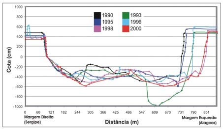
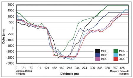
necessarily uniform in all the extension downstream the barrage. The arising of erosive
processes and sediment deposition are evidences of the complex readjustment of the
morphology of the channel in search to arrive at a new dynamic equilibrium.
A relevant conclusion from the impacts studies produced by the great barrages cascade
constructed in the bed of the SÐo Francisco river, on its low course, estuary and adjacent
coastal zone, is that they had occurred (and they continue occurring) in a linked and
hierarchical form, as in other national and international cases, but they demonstrate the
peculiarity of the adjustments to propagate in a spatial and gradual form.
According to several authors, the drastic reduction in the solid load, make that, for one given
outflow, it occurs a surplus of energy equivalent to the one that could be spent in the transport
of the particles. This parcel of energy then is used by the stream flow to excavate its proper
riverbed and, additionally, to erode its edges. It is initiated, in this form, a species of
autophagy: the river starts to pull out its proper sediments, deposited in past times (Figure
25).
Figure 25. Overlapping of the historical
Figure 26. Transversal bathymetric
sequence of transversal
profiles for the SÐo Francisco
bathymetric profiles (1990-2000).
river, in the Prµpria
Piranhas Fluviometric Station
Fluviometric Station gotten
Source: ANEEL/ANA.
between 1990 and 2000.
Source: ANEEL/ANA.
In the geomorphologic compartment immediately downward, between PÐo de AÓºcar and
Proprià (Compartments II and III), the valley widens, but the river continues incased in
metasedimentary rocks and the relief is presented in a strongly waved shape. It is well
possible that in part of this segment it can be occurring the riverbed notching, migration of
riverbed forms (canal bars), associated to the erosion of the edges. In the field recognition it
was evidenced the existence of innumerable erosive focuses in the riverbed edges when
constituted by alluvial sediments and in the emerged islands and bars edges of (Figure 26).
Still following the theoretical model, it is waited that in the following compartment
(Compartment III) it comes to be of accumulation of the removed sediments from the
previous segments. In this compartment, located between Proprià and Penedo, the river cuts
the sedimentary rocks of the Sergipe-Alagoas Sedimentary Basin and alluvial sediments and,
the river develops an ampler flooding plain.
The geometric channel pattern assumed by the river in this compartment, is the interlaced one,
compatible pattern with these hydrosedimentologic conditions, characterized by innumerable
submerged and emersed sandy bars, generally located in the laterals of the channel or
xlv
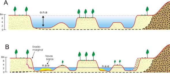
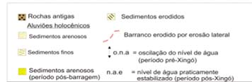
associated to the islands of sandy constitution (in the portions upstream or downstream of
them), that provoke the subdivision of the channel.
The sediment deposition verified in this stretch can, in part, help to explain why exactly it is
the same reached by the marginal erosion. In fluvial channels, the reduction of the depth
tends to be followed by the increase in the width of the channel or trend to the channel lateral
migration that translates in edges erosion, as forms to keep the system dynamic equilibrium.
In the final compartment (Compartment IV), between Ilha das Flores/Neopµlis and the
estuary, the river assumes an anastomosed pattern, where predominate the fixed and vegetated
islands. Generally these islands are located in the riverbed center, forming two main
channels, one in the left edge (alagoana) and another one in the right edge (sergipana), being
this the most prominent. The sandy bars generally are submerged and are developed in these
channels streambed.
9.2. Consideration on the fluvial and estuarine system evolution and new dynamics
after-barrages in the increment of the marginal erosion in compartments III and IV
The morpho-sedimentary reorganization of the low SÐo Francisco happened as a response to
the changes of the sea level since the average Holocene.
The period after Xingµ has been characterized by the decreasing of the channel effective
outflow, therefore, the "stream flow power", and the water level stabilization, these facts that
are taking to the three particular responses: a) the metamorphosis of the system for fixing the
fluvial bars by the vegetation, b) by lateral erosive processes produced by the channel because
this new hydrodynamic situation and c) redistribution of the bottom load under the new
conditions (sprouting of sandy bars inside of the channel) (Figure 27).
Figure 27. Schematically model for the fluvial morphodynamic in the period pre and
after-barrage of Xingµ. A) Period pre-Xingµ. B) Period after-barrage.
The system is passing for a readjustment phase, in response to the new hydrosedimentologic
conditions, in search of a new efficient pattern while the capacity of transport of sediments,
and probably, as it can be seen currently in the redistribution of the sandy sediments, but that
it would have to be proven, adjustment in the sinuosity and amplitude of the talveg wave.
It is interesting to notice that the biggest rate of marginal erosion in areas of low tide influence
is precisely concentrated in segment IV, where the river possesses relatively well developed
xlvi
produced alluvial plain as a response to the adjustments impelled by the trespassing in the
medium Holocene.
The mentioned facts demonstrate the importance of having a schema of the alluvial plain
general evolution and the architecture of its deposits. The morphohydraulic studies that must
be developed as a continuation of this project, will have to strengthen these knowledge's and
the area to be studied would have to be extended at least close to Xingµ dam. The fact to have
a good cartographic base of erosive processes occurrence and a geomorphologic system
compartmentation is a great starting point for the accomplishment of more detailed balances,
but particularly from the morphohydraulic responses in each segment.
9.3. Chaining and hierarchy of the geomorphologic impacts generated by the barrages in
the low SÐo Francisco and comparative analysis with the international study cases
They were identified for the SÐo Francisco river low course, four distinct orders of hierarchies
of related cause and effect, as consequence of the hydro-geomorphologic impacts generated
by Xingµ dam, which include a first approach in the behavior of the current fluvial dynamic
between the barrage and the estuary, in the five main compartments defined in previous items.
This model was elaborated from the geomorphologic, sedimentologic and hydrologic
evidences (Figure 28).
1ˆ orde m (Impac tos diretos , me io fÚsico (fluxo efluente):
- I mpactos no re gime hidro-s edimentolµgico
2ˆ or dem:
Impac tos geomor folµgicos iniciais
(no ca nal e Ãrea marginal inun dÃvel)
Impac tos Indiretos no meio biµtico:
3ˆ or dem:
Impa ctos sobre a fauna e a flora
Ajus tes progress ivos e e nc adeados na
aquÃtic as
mor fodinãmica fluvial
(de m onta nte para jusante)
4ˆ or dem:
Impac tos Indiretos no meio
Impac tos hidro-geomorfolµgicos
antrµpico:
distais
- Impa ctos sµcio-econ¶m ic os
(na à rea m arginal inundÃvel, foz e zona
- Impa ctos cultura is
costeira adjacente)
Figure 28. Hierarchy, chaining and inter-relations among the impacts.
In this way, the main first-order change refers to the alteration in the hydrologic and
sedimentologic regimes. In the second category of effect, resultant from the first order, is
distinguished a set that relates the increase of the flow erosive power, the notch of the
riverbed and the descending of the base level. The third order of effects encloses the changes
in the longitudinal profile and the river gradient; the erosion processes in the edges and the
changes in the transversal profile. In the fourth category the tributaries responses are
xlvii
enclosed, the variations in the piezometric level and the modifications in the estuary dynamics
(river mouth).
Chart 5. Hydro-geomorphologic impacts identified downstream Xingµ, in
agreement with the hierarchic order
IMPACTS FIRST-CLASS (RIGHT-HANDERS)
Alteration in the river flow characteristics and temporality
Alterations in the hydrologic regime
Control of the liquid outflows: effluent flux regularization
Drastic alteration in the seasonality: reduction of the floods intensity and frequency
Alterations in the sedimentologic regime
Effluent flux from the barrage/ Xingµ power plant, practically non supplied with solid
load (retention of the suspended load and from the bottom)
Impacts in the biotic and abiotic medium
IMPACTS OF SECOND ORDER (INDIRECT)
Increase in the erosive power in the channel flow
Notch in the riverbed
Descending the base level and the local water level
Extinguishing of the Marginal Lagoons
Supplement cut of water and sediments for fertile valleys and marginal lagoons
Impacts in the biotic and antropic medium
IMPACTS OF THIRD ORDER (INDIRECT)
Alteration in the performance of the channel processes
Dissemination and potentialization of the erosion processes speed up in the river edges.
Deposition processes in the riverbed: fast formation and migration of new sandy bars in
the channel (sediment deposition)
Alterations in the channel morphology
Changes in the longitudinal profile and in the river gradient (compartments I to IV)
Deposition processes in the riverbed and in the edges. Readjustment of the channel
morphology by the migration of the erosion sectors and sedimentation. The sediment
deposition in the channel can reach long distances
Changes in the transversal profile of the river
Alterations in the morphology of the channel/Change in the configuration (view in
plant).
Propagation of the geomorphologic adjustments from upstream to downstream in result of the
new behavior of the fluvial morphodynamic (after barrages)
Gradual and chained adjustments in the fluvial morphodynamic for the migration of the
erosion sectors and sedimentation, obeying the past geomorphologic compartmentation of the
river
Impacts in the biotic and antropic medium
xlviii
IMPACTS OF FOURTH ORDER (INDIRECT)
Variations in the piezometric level in the marginal areas to the channel
Reduction of the amplitude of the water table level next to the channel, in function of
the control of the outflow (absence of the floods )
Lowering of the water table (in relation to the old period of the year under effect of
floods)
Modifications in the dynamics of the estuary
Drastic reduction in the supply of sediments to the estuary (solid discharge)
Lesser reposition rate of the "praiais"(from the beaches) sediments eroded by the waves
Retrocession of the beach line by erosion
Possible intrusion of saline wedge: in accordance with data gotten from GEF SÐo
Francisco/UFAL the outflows that have been liberated from the UHE Xingµ have been
enough to hinder the entrance of the saline water (sea) in the river.
Impacts in the biotic and antrophic medium
9.4. Theoretical scenery for the evolution of the impacts in the coastal band adjacent to
the estuary (river mouth)
From the analysis of the international study cases and the specific conditions in the coastal
dynamics of the estuary region in the SÐo Francisco river, is reasonable to anticipate that from
a certain time (not estimated) it is possible to occur a still bigger reduction in the supply of
solid discharge to the estuary, as the river reach a new condition of equilibrium.
Thus, would have a trend to the increase in the erosion in the beaches south from the mouth of
the river. What it could be only the beginning of an ampler process, where the erosion tends
to propagate, reaching a considerable extension of beaches in Sergipe north coast, eventually
many kilometers distant from the estuary in the SÐo Francisco river.
Also the waters of the sergipana coast, traditionally less limpid than the alagoana and bahian
coasts, for the presence of sediments in suspension, in its major part having for source the SÐo
Francisco river, will possibly tend to present each time more transparent, in consequence of
the minor supplies of fine sediments and with reduction of nutrients content for the aquatic
fauna.
In case that the environmental picture evolves in this direction, the damages and the impacts
on the ecosystems (also mangroves developed in the estuaries of the north sergipana coast)
and in the socioeconomic activities of the State of Sergipe and this portion of the South
Atlantic will be significant, affecting the fishing, the tourism and the constructions in the
beach band.
9. CONCLUSIONS
In regard to the historical evolution of the marginal erosion in the stretch of Cotinguiba-
Pindoba Irrigated Perimeter
ñ The historical monitoring of the morphodynamic changes in the stretch of the SÐo
Francisco river where is located the Cotinguiba-Pindoba Irrigated Perimeter, demonstrated
that occurred an inversion of the dominant geologic process in the right edge in the
beginning of the decade of 70. Until the decade of 60 the sedimentation predominated,
xlix
but in the beginning of the decade of 70 the place started to be scenery for the
performance of erosive processes, however, in a non-continuous form, once was
intercalated by periods of sediment deposition after the floods . Concomitantly, occurred
the change in the trajectory of the main talveg from the left to the right edge.
ñ Thus, the beginning of the erosive phenomenon in the edge stretch corresponding to the
Cotinguiba-Pindoba Irrigated Perimeter is previous to the implantation of the Irrigated
Perimeter and the construction of Sobradinho dam. However, it was evidenced that the
erosive process in the right edge became accented from the beginning of the decade of 80,
immediately the posterior period to the entrance in operation of Sobradinho hydroelectric
power plant, becoming more aggressive in the end of the decade of 90.
ñ The solutions from the civil engineering used by CODEVASF to contain the advance of
the erosion - adopted always in emergency character and with high cost - had partially
failed, probably due to the lack of previous studies that objectified the understanding of
the fluvial dynamics behavior and to the knowledge of the involved factors and processes,
aggravated by the absence of necessary data of hydrosedimentologic and geomorphologic
monitoring. The conclusion is that the adopted solution Ù the placement of rocks in the
base of the banks Ù it is not efficient to contain the marginal erosion for not considering all
the involved processes and restricting the solution only to the edge itself, without
considering the fluvial and the estuarine dynamics.
In relation to the space distribution of the active marginal erosion focuses and its
morphologic and lithologic characteristics
ñ There were identified up to 57 focuses of fluvial marginal erosion between Proprià and the
estuary of the SÐo Francisco River. In the right edge of the river (Sergipe), the summation
of the lengths of the stretches under erosion results in a total extension of 29.90
kilometers, what means 39.90 % of the length of the edge line. In the alagoana edge, the
marginal erosion reaches a lesser extension, in the order of 17.80 kilometers, what
corresponds to 22.50% of the edge line. In absolute terms, the erosion in the right edge
exceeds to the left by 12.1 km, what represents a difference of 68% between both.
ñ High edges when compared with the medium and low edges, and being submitted to the
same forces, factors and processes, present a bigger effective rate of retrocession. This
because the height favors the arising and the frequency of the controlled mass movements
by the gravitational action.
ñ The lithology and the particle size distribution of the edges constituent material exert an
important role in its degree of stability and function as facilitator or inhibiting factor to the
advance of the marginal erosion. The resistance of the edge to the erosion is directly
related to its lithologic characteristics.
ñ The edges formed essentially for cohesive, clay sediments, are most resistant to the
erosion. However, when they suffer washout in the base and/or they become saturated,
mass movements occur with frequency, as fall of blocks and landslides. The erosive
action on these edges, therefore, is only effective when they suffer the corrosive action
from the stream flow (that provokes washout in the base) or the direct shock of the waves
in the ascents of the tides. The cohesive edges are spatially distributed only in the
neighborhoods of the estuary.
l
ñ Edges formed essentially for non-cohesive sediments (sandy), are highly susceptibles to
the erosion, to depend on the association with other factors and erosive processes. In
terms of spatial distribution, this type of edge occurs in all the studied stretch, but with
bigger concentration in segment IV, between Cotinguiba-Pindoba and Cajaiba.
In regard to the joint action of the erosive processes, to the dynamics and the evolution
of the marginal erosive processes
ñ The erosion of the edges in the SÐo Francisco river low course, apparently a simple
phenomenon, demonstrated to be resulted from the performance of a complexity of factors
and processes, some related to the immediate causes and others to the distant causes, such
as spatial as temporal, related to the dynamics of the fluvial system and to the
interventions provoked by the barrages.
ñ The erosive processes are due to a conjugation of factors related to the fluvial dynamic,
the estuarine dynamic and the artificial oscillations on the river level promoted by the
barrages operation, occurring such in the interval of the river level fluctuation, as in sub-
aqueous form related to the stream flow in the main channel.
ñ In the major part of the stretches of edges under erosion, it is difficult to dissociate the
action of the waves, to the action of the tides (both related with the oscillation of the river
level) and from direct action of the fluvial stream, as where these processes act
concomitantly and/or in a complementary form and the resultant product is the same, that
is, the erosion and, therefore, of the edges lines retrocession.
ñ Despite this difficulty, the analysis of the factors and intervening processes, allowed to
evidence that three distinct sets of processes promote the edges erosion, each one of them
acting in different positions in relation to the river water surface: a) related to the
hydrodynamics in the channel, b) related to the dynamics in the estuary and the artificial
oscillations in the river level and c) related to the geotechnical behavior of the bank
(marginal slope). They act respectively in three positions, in relation to the water surface:
below the river level (sub-aqueous), at the river level and above to this (sub aerial).
ñ The associated performance with these three sets of processes is responsible for the more
effective erosion rates, if the other conditions of susceptibility to the erosion had been
taken care of. The typical case is the stretch located in the Cotinguiba-Pindoba Irrigated
Perimeter right edge, where it reaches the maximum efficiency in the process and velocity
of the edges retrocession by erosion due to a coincidence of conditioning factors.
ñ This model does not apply in the case of the Type A (Pontal da Barra) and B (Saramen)
edges, therefore the erosion in these cases is not associated with the action of the fluvial
stream (sub-aqueous). It occurs in the level of inter-tides, and only in exceptional high
tides occasions, by the direct action of the waves.
ñ The sets of erosive processes resultant from the water action (in the zone of inter-tides and
sub-aqueous) are directly conditioned to the fluvial or to the estuarine dynamics. The
former acts in the upstream- downstream direction and the latter in the inverse direction,
from downstream (estuary/ocean) to upstream.
li
ñ Two patterns of edges (edges under continuous erosion and edges subjected only to
episodic erosion) were identified in relation to the temporal performance form of dominant
processes, which are those intimately related to the environment dynamics that promote
them, respectively, the fluvial and the estuarine dynamics.
In regard to the factors and processes related to the stream flow that participate in the
marginal erosion
ñ In the SÐo Francisco River low course the occurrence of the marginal erosion focuses is
closely related to the talveg proximity to the edge. The talveg trajectory does not
necessarily obey the external tracing of the riverbed fluvial. Its curves do not always
coincide with the external river curves.
ñ About the role exerted by the stream flow action in the edges erosion evolution, it can be
concluded that the continuous work of sub-aqueous particles removal from the main
stream, whose trajectory coincides with the talveg, is in last instance, the great responsible
for the edge lines retrocession. Without this removal the process would not have
continuity. Therefore, the trend would be the bank reaching a balance profile, stabilizing
the edge.
ñ This conclusion strengthens the evaluation of the role exerted by the regularization of
increasing the river potential for the marginal erosion, when favorers the permanence of
the talveg in the same position during several years.
ñ The removed material is, in part, redeposited immediately downstream, promoting
accumulations of sandy sediments in the channel streambed, forming new submerged
sandy banks. The formation and continuous migration of submerged sandy banks/bars,
occupying many times most of the channel, provokes security problems and obstacles to
the fluvial navigation.
In relation to the factors linked to the estuarine dynamics and the role exerted by the
river level fluctuation and the gravitational movements in the evolution of the edges
erosive cycle
ñ The level of the SÐo Francisco River is daily affected by the oceanic tides, as the ascent of
the sea level provokes the natural slide bars in the river flux. The rise and lowering of the
fresh water level in the river, in two daily cycles of high and low tide, exert an important
role in the promotion of the fluvial marginal erosion. As the river level remains more or
less constant (regularized) during all the year, an increasing potential for the action of the
tide on the edge occurs.
ñ The daily fluctuation of the river level has also an artificial origin. The analyzed data
shows that the outflows in the SÐo Francisco river, mainly in the stretch between Xingµ
and PropriÃ, are strongly influenced by the operation rules in the Plant of Xingµ and result
in daily and weekly oscillations of the SÐo Francisco river water levels with amplitude that
vary between 20 and 60 centimeters.
ñ Daily the river level fluctuation (natural or artificial) and the associated waves play an
important role in the maintenance of the marginal erosion evolution cycle. The action of
the waves promotes initially the washout of the bank base. In function of the condition of
lii
created instability, mass movements occur with certain frequency. The moving material is
accumulated in the bank base where it is subjected to pores saturation by water, due to
ascent of the river level and starts to suffer the direct erosive action from the waves.
When falling in the waves action zone, the material will be removed from the bank base
and carried by secondary streams to the fluvial channel main stream.
ñ The exceptional variations in the tides amplitude caused by episodic events, increase the
tides erosive effect potential in the fluvial edges located in the estuary neighborhoods and
reach some edges not submitted to the daily erosion.
ñ The material removal that accumulates in the edges base by the waves has, besides its
direct erosive action, an indirect basic consequence to keep the continuity of the edges
retrocession evolution process: it prevents thus that the edge comes to reach its
equilibrium profile. If such happens, could take the interruption of the edge retrocession
process, until another agent (in the case, the flow of the channel) provokes the erosive
cycle restart.
ñ In the river stretch between PÐo de AÓºcar and PropriÃ, the daily artificial oscillation of
the river level is the main responsible for the marginal erosion, when provokes the rise of
the water table level, which in association to the waves action, promotes the removal of
constituent sandy particles from the sedimentary edges base.
In regard to the form, how the promoted outflows regularization by the great dam
influences the marginal erosion
ñ The long duration of the average outflow regularized by the dams operation implies in the
river level permanence in a determined platform during a very long period, in average
levels relatively raised in relation to its previous conditions, what contributes to the
destabilization of the edges constituted of fluvial or littoral sediments.
ñ Moreover, the line incidence permanence over the main flow in a determined edge stretch
submitted to the erosion and the summation consequence of the edge retrocession rate
along the years, can result in a more expressive value than would be expected in a natural
picture. This phenomenon was particularly observed in the band corresponding to the
Cotinguiba-Pindoba Irrigated Perimeter .
ñ This context does not apply to all situations. For times exactly the opposite occurs: in
some river stretches, small present changes in the talveg stretches had been identified as
consequence of the recent migration of sub-aqueous sandy bars provoked by the channel
sediments remobilization and the edges materials removal by the erosion. This means
that, even lesser rhythm, the changes in the talveg position continue to occur, stimulated
not by the great outflows, but by an effective outflow that makes possible the deep load
transport (sands) as diminishing the channel useful area and, forcing its lateral migration,
which configures it in a fluvial marginal erosion form.
In regard to the river natural seasonality alteration promoted by the great dams and,
the consequences for the marginal erosion
ñ The outflows historical series analysis allowed to identify that, the interannual variations
and its seasonality in the SÐo Francisco River low course, present four distinct hydrologic
liii
regime behavior phases. The first phase corresponds to the natural regime and the
following phases had been attributed to the influences of the successive constructions of
upstream dams. These river hydrologic regime alterations had not been clearly established
in the previous works, since the data were treated as a continuous historical series, which
masked the influence of each identified period.
ñ In the Sobradinho dam immediately posterior construction period (1978-1987) a rise of
the minimum outflows occurred, but the strong annual outflow peaks (summer
characteristic) remained. Although the Sobradinho great capacity of floods
regularization, the floods, even partially attenuated, continued to occur annually, as in the
natural regime.
ñ The frequency of floods in the Low SÐo Francisco only had been substantially reduced
after 1987-1888, time coincident with the Itaparica dam construction. Even possessing
only a small regularization capacity the Itaparica dam plays an important role in the
retention of the outflows produced in the sub-medium SÐo Francisco, downstream
Sobradinho. These contributions were cyclically the responsible to the floods potentiality
in the low SÐo Francisco.
ñ The period after-construction of Xingµ (1994-2001) was marked by the total lack of
floods or even high outflows peaks. This fact led to the false conclusion from several
technicians and from the riverine population that the floods would no more occur in the
low SÐo Francisco, due to the Xingµ dam outflows control. In fact, a temporal
coincidence between the two facts exists, but Xingµ is not responsible for the containment
of eventual floods, being a barrage that works in a "Fio d'Ãgua" ("the water line") regime.
Depending on the incoming water to Sobradinho and Itaparica, the floods would be able to
occur again in the low SÐo Francisco.
In relation to the dams sediments retention and the alterations in the downstream
sedimentary transport
ñ Among the several impacts resulted from the upstream big dams, a large amount of
reservoirs sediments retention proceeding from upstream is the most responsible for the
dynamic interventions in the river stretch downstream Xingµ dam, when modify
substantially the characteristics of the effluent flows from the dam. The Xingµ dam
represents the final link in the sediments retention chain from upstream. Downstream
Xingµ, the water is excessively limpid and the total solid load currently carried represents
only about 4 % of the values occurred before the upstream dams construction.
ñ Eventually a temporary change in this picture can occur: the occurrence of high outflows
episodes from exceptional rain events in the high, medium or sub-medium SÐo Francisco,
can imply in a drastic reduction of the normal water permanence time in the reservoirs,
making the load suspended values substantially raise in the dams effluent fluxes.
ñ As the solid particles are almost totally retained in the upstream reservoirs, the present
sedimentary load carried by the river is due to a production (small when compared with
the natural values) originated from the own channel: the material removed by the edges
erosion, by the riverbed affluents erosion, and in a very small scale, from the sub-basin
affluents. The marginal and the channel bed erosion contribute to the channel localized
liv
sediment deposition process, what in some of the river stretches, leads to the edges erosive
process feedback.
In relation to the new fluvial dynamics behavior and the forms of the morpho-dynamic
adjustments propagation in several channel compartments, in response to the changes of
the hydro-sedimentologic regime imposed by the dams
ñ In order to establish an adequate understanding of the fluvial system behavior before the
hydro-sedimentologic changes imposed to the downstream stretch by the great dams, it
was necessary an including analysis, as much of the spatial as the temporal point of view.
It can be concluded that the morpho-dynamic responses to these changes depend on the
morpho-structural conditionant and the geologic history, which conditioned the evolution
of the fluvial and the adjacent littoral system.
ñ It was concluded that the low SÐo Francisco River downstream Xingµ is characterized by
a controlled evolution with a morpho-sedimentary compartmentation, being able to be
divided in five geomorphologic compartments, defined by lithologic, topographical and
structural controls, which probably controlled the fluvial system evolution. From
upstream to downstream, the channel pattern passes successively from an unique incased
channel in the relief (canyon), in compartments (I and II), which has basically acted as
corridor for sediments, not registering fluvial depositional forms of importance, to a
pattern of slightly sinuous channel and with low coefficient of interlacement between
islands and sandy bars and presenting an alluvial plain little developed (Compartment III).
ñ In the compartment IV it is less incased, with an alluvial plain wider and develops a more
complex model, with an interlaced multichannel pattern. The larger density of islands
and emerged/submerged sandy bars probably indicates that, along the river geologic
history, this compartment functioned as an accumulating zone for alluvial sediments
proceeding from upstream. In the final compartment (V) the channel is characterized for
assuming an anastomosed pattern where the channels are deeper and widely prevailing the
great fixed islands formed by fine materials (silte and clay) and stabilized by the
vegetation.
ñ The studies allowed concluding that the river did not respond in a linear form to the
changes in the hydro-sedimentologic regime. The channel responses to the 1st order
impact represented by the reduction in the acquisition of the solid load (that stays retained
in the reservoirs) are not uniform in the entire extension downstream Xingµ dam. This
stretch is being submitted to the morpho-hydraulics and sedimentary complexes
readjustments that advance gradually and in a chained form, from upstream to
downstream, till the estuary.
ñ The adjustment forms of propagation vary according to the Geomorphological
Compartments of the SÐo Francisco River low course. The five compartments allowed the
river, after the successive constructions of the dams, especially after the construction of
the Xingµ dam, to begin a differentiated adjustment.
ñ The arising of erosive processes and sediment deposition along the river stretch located
downstream the Xingµ dam are evidences of the complex channel morphology
readjustment in search of a new dynamic equilibrium. These morpho-sedimentary
responses must be understood in a spatial context from the stretch immediately
lv
downstream the dam till the SÐo Francisco River estuary. In relation to the marginal
erosion problematic, the relevant fact is that the present marginal erosions are inserted in
the context of the adjustments for which the fluvial dynamic has been passing. Therefore,
it does not have to deal with the problem only as of local order, but inside an ampler
context, inserted in a picture of great changes in the river morphodynamic.
ñ Compartment I responds in accordance with the available dams impacts model in the
international literature. The typical behavior of the channel segment immediately
downstream the dam, resulting from the drastic reduction in the solid load is the riverbed
notching. It was proved, through analyzes of the bathymetric profiles historical series, that
the valley deepening and widening in this compartment, with the erosion of the mobile
riverbed and probably the exposition of hard rocky substratum.
ñ In the geomorphologic compartments immediately downstream, between PÐo de AÓºcar
and Proprià (Compartments II and III), it is occurring the riverbed notching and migration
of riverbed forms (channel bars), associated with the edges erosion. In the field survey it
was evidenced the existence of innumerable erosive focuses in the riverbed edges when
consisted by alluvial sediments and in the edges of islands and emerged bars.
ñ In the following compartment (Compartment IV), between Proprià and Penedo, it is
occurring accumulation of the removed sediments from the previous segments. The
sediment deposition verified in this stretch can, in part, to explain why it is exactly the
most affected by the marginal erosion. In fluvial channels, the depth reduction tends to be
followed by the increase in the channel width or the trend to lateral channel migration that
translates in edges erosion, as a way to keep the dynamic equilibrium in the system.
ñ In the final compartment (Compartment IV), between Ilha das Flores/Neopµlis and the
estuary, apparently it is the river sector less reached by the adjustment process. Compared
to the previous geomorphologic compartment, the erosion is less accentuated and more
localized. The differentiated morphologic forms that occur in this compartment will come
to modify, in virtue of the erosion and sedimentation sectors migration, in the downstream
direction, once, with time passing, the sediment deposition in the channel will be able to
exceed the limits between compartments IV and V.
ñ In this case, changes in the morphodynamic can be expressive, leading to the similarity
with compartment IV, to the accentuation of the marginal erosive process and gradual
sediment deposition from upstream to downstream. Such changes certainly would be
reflected in the biota and in the river uses by man (fishing, tourism and navigation).
ñ The understanding that the readjustments in course obey the morpho-structural
conditionings will be able to direct future monitoring, interventions, management of the
fluvial ecosystem and hydro-environmental changes evolution forecast.
In relation to the causes, to the chaining and hierarchy of the geomorphologic impacts
generated by the dams and comparative analysis of the international study cases
ñ The studies have confirmed that the SÐo Francisco river low course has been suffering a
series of morpho-hydraulic adjustments as a response to the direct impacts promoted by
the great dams. These adjustments advance gradually and in a chained way, from
upstream to downstream, and its propagation forms occur in a differentiated way in each
lvi
one of the five geomorphologic compartments controllers of the SÐo Francisco river low
course evolution.
ñ They were identified for the low course of the SÐo Francisco river, four distinct orders of
hierarchies of related cause and effect among them, as consequence of the hydro-
geomorphologic impacts generated by the barrage of Xingµ, which include a first
approach for the current fluvial dynamics behavior between the barrage and the estuary, in
the five main compartments defined in the previous items.
ñ In this way, the first-order changes (impacts in the hydro-sedimentologic regime) are
followed by a second effects category (initial geomorphologic impacts), which reaches
either the marginal area subject to flooding and the fluvial channel, where the increase in
the flux erosive power occurs, resulting initially in the riverbed notch. The third order of
effects (gradual and chained adjustments in the fluvial morphodynamic) comprises the
changes in the erosion sectors (notch and erosion of the edges) and sedimentation along
the fluvial geomorphologic compartments. In the fourth category (distal hydro-
geomorphologic impacts) are enclosed the tributaries responses, the variations in the
piezometric level and the modifications in the estuary dynamics.
ñ The comparative analysis of international study cases, demonstrated that the hydro-
geomorphologic alterations in the Low SÐo Francisco correspond, in general, to
predictable potential effects, in accordance with the observed in other rivers with dams.
But they present certain peculiarities, in function of the bottom and the edges lithologic
constitution, the interaction with the coastal dynamic and of the configured morpho-
structural controls through the geomorphologic compartments. Moreover, they are
distinguished for the rapidity (few years) in that the morpho-dynamic responses were
revealed, for its magnitude, amplitude, ample space distribution, for the gravity of the
hydro-environmental and social-economic-cultural problems generated throughout all the
fluvial system downstream the dam (till the estuary, 256 km from the dam body) and
adjacent coastal zone.
ñ On the other hand, it was demonstrated that such picture of environmental degradation
was already predictable from the available international knowledge by the time of the
Xingµ dam construction. However, these considerations were not reported neither in the
studies of environmental impacts of the UHE Xingµ and in the subsequent programs of
environmental monitoring, agreed between CHESF and IBAMA. These monitoring had
been limited till some few kilometers downstream the Xingµ dam, where the river is
relatively steady and incased in hard rocks, to the step that, the great hydro-environmental
modifications start to become more evident in distances bigger than 100 km from this
place. As it was known, the state and municipal authorities and the riverine population
were not enough clarified about these consequences, resultants of the solid load and
nutrients "confiscation" and the changes in the hydrologic regime and, neither, were
established compensatory and mitigatives measures for the impacts in the fluvial and
littoral ecosystems and in the antropic medium.
ñ The general conclusion that can be presented about the primary causes which lead to the
deflagration of the current phase of accelerated marginal erosion, was that the great dams,
as they had established a new hydro-sedimentologic regime and they had induced a new
morpho-dynamic behavior, they can be considered as the main responsible for the
lvii
dissemination of erosive focuses and the increment of the fluvial edges rate of
retrocession.
ñ The understanding that the fluvial system is passing for a readjustment phase, which
possibly will result in the establishment of a new dynamic equilibrium with the new
conditions resulting from the construction and operation of the great dams, stands out the
importance in establishing permanent mechanisms for the environmental systems
evolution monitoring, also as a form to make possible the prediction of future scenarios,
allowing the formularization of mitigating actions proposals, as well as the eventual
hydro-environmental revitalization actions effects quantification.
Regarding to the theoretical scenarios for the evolution of the impacts in the adjacent
coastal band to the estuary
ñ From the analysis of the international study cases and the specific coastal dynamic
conditions in the region of the SÐo Francisco river estuary, it is reasonable to predict that
from a certain time (not estimated) an even bigger reduction is possible to occur in the
supplying of solid discharge to the estuary, as the river reach a new condition of dynamic
equilibrium. It is estimated that probably from this moment on will occur an aggravation
of the disequilibria between the river and the ocean water action.
ñ Thus, would have a trend to the increase of the beaches erosion located south from the
mouth of the river. What could only be the beginning of an ampler process, where the
erosion tends to propagate, reaching a considerable extension of Sergipe north coast
beaches, eventually distant many kilometers from the SÐo Francisco river estuary.
ñ In the recent geologic dynamic in the estuary adjacent coastal zone it is to be expected that
the episodes of accented beaches erosion could be later compensated with incoming new
sediments in part coming from the SÐo Francisco river, occasion when the beach bands
returned to be recovered. With the drastic reduction of the fluvial contribution to the
coastal zone, the risk of the losses of coastal areas, by erosion, is visualized, if the current
environmental conditions become irreversible.
ñ In case that the environmental picture evolves in this direction, the damages and the
impacts on the ecosystems (also mangroves developed in the estuaries of the north
sergipano coast) and the socioeconomic activities of the State of Sergipe and this portion
of the South Atlantic will be significant, affecting fishing, tourism and civil constructions
in the beach band.
ñ These possible impacts will be able to extend the gravity and the geographical amplitude
of the environmental problems faced by the region, in result of the changes imposed to the
SÐo Francisco River by the great dams construction and operation. In this direction, the
region is demanding a continuous and detailed monitoring, of basic importance for the
measures proposal to attenuate these modifications.
lviii
11. RECOMMENDATIONS
Considering the conclusions obtained in this study, four recommendations were elaborated
aiming the more detailed knowledge of the identified problems:
11.1. Recommendations about the river multiple environmental monitoring and inter-
institutional articulation: Implantation of a research network and the river and its
estuary permanent hydro-environmental monitoring
Period
GEF Counterpart
Total
Title
(months)
US$
US$
Cost US$
Implantation of a research network and the
river and its estuary permanent hydro-
24 170,000
360,000 530,000
environmental monitoring
Monitoring the evolution of the
morphodynamic adjustments spatialization
24 150,000
300,000 450,000
model in the SÐo Francisco river low course.
Study of solutions and elaboration of
executive project for the containment of the
edges erosion in the irrigated perimeters in
24 100,000
200,000 300,000
the SÐo Francisco river low course,
including execution in testing area.
Geomorphologic evolution in the Low SÐo
Francisco during the Holocene and the
possible environmental implications in the
24 100,000
200,000 300,000
coastal zone as resulted from the interaction
with the fluvial dynamics after-dams.
Knowledge of the problem and the work justification
In the last years, the aggravation of the environmental and socioeconomic problems in the
region of the low SÐo Francisco has raised to the conduction of innumerable research and
planning. Despite the relatively high number of produced works, few have contributed for the
environmental and socio-environmental reality transformation.
One of the reasons alleged for the low effectiveness of the innumerable plans, programs and
projects have been the lack of a coordinate action that allows the reduction of the dispersed
efforts, works overlapping and consequent resources wastefulness.
In that it refers specifically to the research in the SÐo Francisco river, its area subjected to
marginal flooding, tributaries and adjacent coastal zone, the lack of articulation among the
institutions and groups of research that acts in the region has also contributed for a production
directed mainly toward the collection of data, but without a commitment with the search for
answers to the relevant hydro-environmental problems present for the region and its
inhabitants.
The GEF/UFAL/UFS studies indicate the necessity for a new aiming in the strategies and in
the types of data to be collected, considering the new interests, magnifying the knowledge in
the behavior of nutrient, hydro-environmental, hydro-sedimentologic, geomorphologic,
lix
chemical and aquatic fauna variables. In order to attend the multiple uses of water and the
knowledge about the impacts produced by the great dams construction and operation in the
SÐo Francisco River low course, its estuary and adjacent coastal zone.
The finding that the fluvial system is in process of readjustment in response to the changes
produced by the dams and considering that is a process of long time period, leads to conclude
that the survey realized by the GEF SÐo Francisco Project registers only one stage, not being
enough to make reasonably safe forecasts about the evolution of the hydro-environmental
picture and future scenarios necessary to base proposals of mitigative measures and
environmental management.
The necessity of a continuous monitoring, in a way to follow the fluvial system dynamic and
the associated ecosystems evolution, is the only form to guarantee safe interventions and a
guide for mitigative measures. The isolated and partial surveys are not enough to allow the
proposition of management and mitigatives measures, as establish a new base of ecological
and socio-environmental co-habitation with the river "artificialized" and regularized by the
great dams.
Actions
In this way, it is recommended the establishment of a permanent monitoring system in the SÐo
Francisco river, the marginal flooding areas, its tributaries, its estuary and in the adjacent
coastal zone, using the regional institutions existing base, in particular, the Federal
Universities, Agencies of Environmental Management and Water Resources, ONGs and the
Xingµ Institute in the States of Sergipe and Alagoas, involving partnerships with institutions
and groups of research in other States.
The interinstitutional arrangement to be considered should be the product of an ample
negotiation in the direction to potentialize the joint performance of the operating institutions
already in the region, with the exploitation of the existing infrastructure, including
laboratories, the development programs and the research groups working in the region,
minimizing the physical structure investments and preventing the allocation of material and
human resources in only one institution.
Strengthening and making viable local research groups focused in the region hydro-
environmental and ecological problems, through the creation of a research network, can make
possible the development of a space for understanding and integration which could result in
the research attitudes reorientation to focus in the solution of the problems and the hydro-
environmental revitalization and, the development of compatible methodologies, capable to
establish indicators and to generate indexes, which will make possible to evaluate the
evolution of the environmental quality.
The monitoring planning will have to take in consideration the existence of several
geomorphologic and hydrodynamic river compartments that probably should have
correspondence with the behavior of the fauna and aquatic flora. The processes with chained
and spatial adjustment, deduced from the geomorphologic evidences in the GEF SÐo
Francisco 2.4 subproject would be object of evidence in the program-monitoring occasion.
The main predicted thematic lines in the monitoring must necessarily have a multidisciplinary
character, approaching the physical, biotic and socioeconomic aspects, including: icthyofauna
lx
and its nutrients, plankton and monitoring the fishing activities and, the results for alevin
repopulation (genetic marking); solid loads carried by the river (deep and suspended load);
bathymetry and fluvial morphology; tributaries contribution (liquid and solid discharge,
nutrients); aquatic plants, edges vegetation; water quality (also in regard to polluting agents);
the estuary incoming mensuration and accompaniment of the estuary and adjacent coastal
zone dynamic.
The predicted costs are of USS 170,000 for the financing source and the counterpart of the
involved institutions might totalize U$ 360,000.
11.2. Recommendations about the detailing of the monitoring morphodynamic
adjustment component in the channel and in the estuary marginal erosion:
Monitoring the evolution of the morphodynamic adjustments spatialization model in the
SÐo Francisco river low course.
Justificative for the Work
The results from the mentioned GEF SÐo Francisco 2.4 sub-project, had demonstrated that
intense erosive processes are occurring in the edges of the low SÐo Francisco as well as in its
estuary. The quantification of the changes and adjustments in the morpho-hydraulic system
variables and its comparison with the periods before and after the dams result in basic
importance to understand the distribution of the erosive focuses as well as to subsidize the
decisions about the engineering work that should be constructed for the edges protection.
The project 2.4 results have evidenced that the compartmentation of the SÐo Francisco can be
changed into a valuable management tool.
From the geomorphologic and sedimentologic point of view the monitoring of the SÐo
Francisco river low course and the adjacent beach zone to its estuary will allow to know better
and to quantify the mobilization of the river solid load, to verify with more detail the
morphologic channel responses and to prove the model considered in GEF 2.4 subproject,
which studies the morphodynamic adjustments processes spatialization and the sectors where
the erosion or the sedimentation predominates.
Once the considered model presuppose that some compartments behave preferentially as
sedimentary particle source area for the river solid load (through the riverbed notching),
others as passage area, and others as preferential accumulation area and, even situations of the
edges erosion and riverbed sedimentation, it is necessary to prove and to quantify the solid
load movement between the compartments, which will serve to establish in a more
appropriated form the initially considered model and to allow monitoring its evolutive trend,
once the solid load supply cut (retained in the dam) created a disequilibria situation, for which
the river is adjusting.
Thus it is recommendable to follow the evolution of these processes, since the physical and
biological conditions, still tend to be modified along the time, until reaching a new pattern of
equilibrium. However, these changes would be able to affect the diverse fishing resources
supplied by the river and would have sharper consequences on the antropic medium.
The predicted duration is 24 months, with a cost of US$ 150,000 for the financier source and
of USS 300,000 for the counterpart. The preliminary calculation of this budget is based on
lxi
the execution of the project by a local team, with proven experience in the considered services
and in fieldwork in that region, complemented by external consultants contract.
11.3. Recommendations for studies of solutions for the containment of the edges erosion
in the irrigated perimeters in the SÐo Francisco river low course: Study of
solutions and elaboration of executive project for the containment of the erosion in the
edges of the perimeters irrigated in the SÐo Francisco river low course, including
execution in test area.
Knowledge of the problem
Among the current environmental problems in the SÐo Francisco river low course, the
marginal erosion speedup stands out for its visibility, amplitude, ample distribution and
socioeconomics and hydroenvironmental consequences. The problem of the edges erosion in
the low SÐo Francisco has generated an increasing reduction of the production areas in the
irrigated perimeters existing in that area, causing damages for the two States (Sergipe and
Alagoas).
The edges erosion in the SÐo Francisco river low course assumed more drastic proportions in
two stretches in the right edge, where, coincidently, the Cotinguiba-Pindoba and the Betume
irrigated perimeters meet, both implanted by the CODEVASF in the end of the 1970 decade.
The engineering solution used by CODEVASF for the containment in these stretches has been
of emergency character and has consisted of an arrangement of large stones covering the base
of the marginal slopes "enrocamento" and the reconstruction of the marginal levees in more
recoil position in relation to the original edge line. These solutions, however, are palliative
and have a high financial cost.
The recent studies of GEF SÐo Francisco Project, through Subproject 2.4 (Fontes, 2002),
demonstrated that the imperfections in the adopted solution have occurred in function of this
procedure not be adequate to avoid the more effective erosive process Ù the action of the
fluvial stream Ù which acts in the sub-aqueous level, below of the band protected by the
placement of rocks.
The demonstrated relevant fact is that the observed marginal erosions are inserted in an
adjustment context for which are passing the fluvial dynamic, as a result of the hydro-
sedimentologic and geomorphologic impacts by the great dams, along the SÐo Francisco river
course. Therefore, it does not have to deal only with the local order problem, trying only to
protect directly the edge, but in an ampler context, inserted in a picture of great changes in the
river morphodynamic.
It is recommended to appreciate the possibilities displayed below, including the evaluation of
its environmental impacts, without damage for other options inclusion. The main objective in
the three presented proposals is to obtain the erosion reduction by the talveg relocation,
redirecting the main draining river channel, with the use of techniques that must be evaluated
about the minimization of the negative environmental impacts (also visual or to the
navigation) or that would provoke the beginning of new erosive focus downstream or
upstream the river intervention place.
lxii
ñ It is recommended the proposals analysis presented to CODEVASF for containment of the
erosion through the use of the Hydraulic Dragging (POTAPOV method) technique.
ñ Analysis of the proposal presented by CODEVASF consultants (Canalli e Agrar
Consultoria, 2000), which recommends the construction of perpendicular submerged
ridges to the edge with the use of bags confectioned with permeable material ("geotextil")
and filled with riverbed or edge sand.
ñ Analysis of the provocative proposal about artificial floods, which would have the role for
eliminating the channel obstruction, creating new talveg trajectories. In this case an
analysis in reduced or virtual model is recommended. The option for this model would
have to pass necessarily for the accomplishment of a flood-test, preceded by a detailed
survey of the channel bathymetry/morphology, as well as the accomplishment of new
survey after its occurrence for the evaluation of its results and orientation about the
definitive proposal
Presentation of a flood transmission model, specifically elaborated to subsidize the studies of
erosion/sedimentation and the annual flood mitigative proposal about production of artificial,
flood as a form to minimize the problem of the marginal erosion.
Once the solutions regarding to the sub-aqueous erosion caused by the fluvial stream are
proposed, actions for the minimization of the waves and transversal secondary streams erosive
process, would have to be studied. They act in the river level oscillation interval. Therefore,
avoiding if possible, the use of rocks placement "enrocamento" due to the interference that
they create in the landscape and in the navigation.
Actions should be proposed for the edges recovery, parallels to the stabilization process, with
the preferential use of revegetation techniques with native species and recovery of margin
bushes in a sustainable form. The use of the vegetation alone will have to occur only after the
stabilization process has been initiated, as was already demonstrated (Fontes, 2002), in a
general way, the current erosion occurs below the trees roots level, therefore, the vegetation is
not an efficient way in controlling the erosions related to the talveg action. However, they
play an important role in the protection of the edges after their stabilization, in the
landscaping recovery and for the fluvial aquatic ecosystem.
It is recommended the accomplishment of a field experiment, preceded or not by simulation,
for the results and recommended solution evaluation, before the elaboration of the final
Executive Project.
The predicted duration for the project is of 24 months, with costs of U$ 100,000.00 for the
financial Source and Counterpart of U$ 200,000.00.
11.3. Recommendations about the management of the coastal zone (coastal north of
Sergipe): impacts of the changes in the fluvial dynamic on the evolution of the
beach zone: geomorphologic evolution of the Low SÐo Francisco during the holocene
and the possible environmental implications in the coastal zone as resulted from the
interaction with the fluvial dynamics after-dams
The results of GEF SÐo Francisco subproject 2.4, have demonstrated that intense erosive
processes are occurring in the low SÐo Francisco edges as well as in its estuary. The results of
lxiii
project 2.4 have evidenced that the SÐo Francisco compartmentation can turn into a valuable
management tool.
The SÐo Francisco river "delta" construction, which is presently under erosion stage in some
sectors, it is a product of the fluvial and coastal system evolution associated to the sea
trespassing in the medium Holocene. Although several studies have been developed in the
delta and in the coastal region, the knowledge of the fluvial system as well as the morpho-
sedimentary responses and the climatic changes in the Holocene are practically inexistent.
In order to improve the knowledge on the fluvial system functioning, it is necessary to extend
the considered temporal scale, elaborating a basic model of functioning, more detailed in the
Holocene, in the pre-impact antrophic period.
The elaboration of detailed maps about the geomorphologic units that compose the Low SÐo
Francisco alluvial plain as well as of its architecture sedimentary will allow a better
understanding of the distribution and behavior of the fertile valley areas and other units of the
alluvial plain as well as of the region of coastal transition, which are submitted to the intense
human being handling and occupation. The understanding of the historical interactions
between the fluvial and coastal dynamics and the answers in the shoreline, can consist in an
essential base for the understanding of the future evolution of the coastal zone situated
southern of the SÐo Francisco river estuary (northern Sergipe coast), allowing the elaboration
of evolutions scenes, that come to subsidize the proposal of mitigatives measures.
The considered services objectify to elaborate maps of the alluvial plain morpho-sedimentary
units, to characterize its hydro-geomorphologic dynamics, and to elaborate an evolutive
model for the system since the average Holocene and, to present procedures of
use/management and protection for critical areas, including also the eventual proposition to
create a APA. (Environmental Protection Area).
The predicted duration is 24 months, with costs for the Source Financier of US 100,000.00
and for the counterpart of U$ 200,000.00. The preliminary calculation of this budget is based
on the project execution by a local team with external consultants participation.
lxiv